NASA provides a look at post-blizzard snowfall and winds
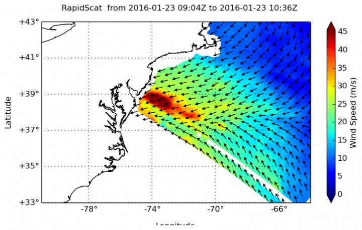
On Jan. 23 at 5 a.m. EST, RapidScat showed sustained winds as strong as 45 meters per second (100 mph/162 kph) along the coast of southern New Jersey, which included areas from Cape May to Atlantic City. Credits: NASA JPL, Doug Tyler
The RapidScat instrument flies aboard the International Space Station and measures surface winds over the ocean. On Jan. 23 at 5 a.m. EST, RapidScat showed sustained winds as strong as 45 meters per second (100 mph/162 kph) along the coast of southern New Jersey, which included areas from Cape May to Atlantic City. Those winds led to flooding along coastal areas.
After the storm had moved off into the Atlantic Ocean, NASA's Aqua satellite passed over the eastern U.S. The Moderate Resolution Imaging Spectroradiometer or MODIS instrument aboard captured a visible-light image on Jan. 24 at 1830 UTC (1:30 p.m. EST) that showed a blanket of snow on the ground stretching from southeastern Massachusetts to southeastern Missouri.
The Operational Land Imager (OLI) on Landsat 8 captured a natural-color image of Virginia, Maryland, and Washington, D.C. on January 24, 2016. Most neighborhoods in the image received at least 18 to 24 inches (46 to 61 centimeters) of snowfall from the nor'easter that pounded the region from January 22 to 24.
Some areas along the New Jersey coastline were flooded as winds pushed the ocean waters inland, and serious beach erosion was reported. Philadelphia's NBC Channel 10 interviewed the mayor of North Wildwood, New Jersey who said the flooding on the morning of Saturday, January 23 was half a foot higher than what the town experienced during Superstorm Sandy in 2012.
RapidScat is an important tool for meteorologists, because maximum sustained winds are not always equally distributed in a storm. RapidScat shows forecasters the location of the strongest winds in different quadrants of a storm, indicating locations facing greatest impacts.
Landsat 8 (formerly the Landsat Data Continuity Mission, LDCM) is a joint mission between NASA and the U.S. Geological Survey. It is collecting valuable data and imagery to be used in agriculture, education, business, science, and government. The Landsat Program provides repetitive acquisition of high resolution multispectral data of the Earth's surface on a global basis.
For NASA coverage of this historic storm, visit: http://www.
Media Contact
All latest news from the category: Earth Sciences
Earth Sciences (also referred to as Geosciences), which deals with basic issues surrounding our planet, plays a vital role in the area of energy and raw materials supply.
Earth Sciences comprises subjects such as geology, geography, geological informatics, paleontology, mineralogy, petrography, crystallography, geophysics, geodesy, glaciology, cartography, photogrammetry, meteorology and seismology, early-warning systems, earthquake research and polar research.


Newest articles

Properties of new materials for microchips
… can now be measured well. Reseachers of Delft University of Technology demonstrated measuring performance properties of ultrathin silicon membranes. Making ever smaller and more powerful chips requires new ultrathin…

Floating solar’s potential
… to support sustainable development by addressing climate, water, and energy goals holistically. A new study published this week in Nature Energy raises the potential for floating solar photovoltaics (FPV)…

Skyrmions move at record speeds
… a step towards the computing of the future. An international research team led by scientists from the CNRS1 has discovered that the magnetic nanobubbles2 known as skyrmions can be…

