NASA measures rainfall in newborn Tropical Cyclone Corentin
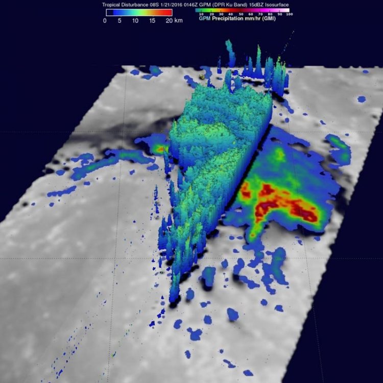
On Jan. 21 at 0146 UTC GPM saw rain at a rate of over 71 mm (2.8 inches) per hour in strong storms to the northeast Corentin's center. Cloud tops were reaching heights of almost 13 km (8 miles) in the intense feeder band west of the low's center of circulation. Credits: NASA/JAXA/SSAI, Hal Pierce
The GPM core observatory satellite saw the developing tropical cyclone east of Madagascar on January 21, 2016 at 0146 UTC (Jan 20 at 8:46 p.m. EST). GPM is a mission that is co-managed by both NASA and the Japan Aerospace Exploration Agency.
When GPM flew over the developing tropical cyclone Corentin, GPM's Microwave Imager (GMI) and Dual-frequency Precipitation Radar (DPR) measured precipitation. The most intense showers were dropping rain at a rate of over 71 mm (2.8 inches) per hour in strong storms to the northeast of the tropical low's center of circulation. GPM's radar (DPR) viewed a swath of data to the west of the developing tropical cyclone center where rain was measured falling at a rate of over 80 mm (3.1 inches) per hour.
At NASA's Goddard Space Flight Center in Greenbelt, Maryland, data derived from GPM's DPR (Ku Band) was used to create a 3-D view of the storm. The 3-D image showed that storm tops were reaching heights of almost 13 km (8 miles) in the intense feeder band west of the low's center of circulation.
At 1500 UTC (10 a.m. EST) on Jan. 21, the first bulletin on Tropical Cyclone Corentin centered the storm near 15.9 degrees south latitude and 73.6 degrees east longitude, about 532 nautical miles south of Diego Garcia. Corentin had maximum sustained winds near 35 knots (40 mph/62 kph). It was moving to the west-southwest at 10 knots (11.5 mph/18.5 kph).
Corentin is expected to move southwest, steadily veering south and southeast. The storm will intensify to 80 knots before veering southwest again and weakening.
Media Contact
All latest news from the category: Earth Sciences
Earth Sciences (also referred to as Geosciences), which deals with basic issues surrounding our planet, plays a vital role in the area of energy and raw materials supply.
Earth Sciences comprises subjects such as geology, geography, geological informatics, paleontology, mineralogy, petrography, crystallography, geophysics, geodesy, glaciology, cartography, photogrammetry, meteorology and seismology, early-warning systems, earthquake research and polar research.


Newest articles

Properties of new materials for microchips
… can now be measured well. Reseachers of Delft University of Technology demonstrated measuring performance properties of ultrathin silicon membranes. Making ever smaller and more powerful chips requires new ultrathin…

Floating solar’s potential
… to support sustainable development by addressing climate, water, and energy goals holistically. A new study published this week in Nature Energy raises the potential for floating solar photovoltaics (FPV)…

Skyrmions move at record speeds
… a step towards the computing of the future. An international research team led by scientists from the CNRS1 has discovered that the magnetic nanobubbles2 known as skyrmions can be…

