NASA infrared satellite data gives System 96S a fair shot at becoming a tropical cyclone
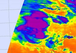
A NASA AIRS instrument infrared image captured on Feb. 9 at 17:47 UTC (12:47 p.m. EST) showed some strong convection and strong thunderstorms (purple) with very cold cloud-top temperatures, around the center of System 96S. Credit: NASA/JPL, Ed Olsen<br>
When Aqua passed over System 96S on Feb. 9 at 17:47 UTC (12:47 p.m. EST), the Atmospheric Infrared Sounder (AIRS) instrument showed some strong convection and strong thunderstorms with very cold cloud-top temperatures around the center of circulation.
Those cloud top temperatures were as cold as or colder than -63 Fahrenheit/-52 Celsius indicating strong convection, strong thunderstorms, and heavy rainfall. The imagery suggests that the convection is consolidating and increasing around the low's center.
Convection is limited on the eastern half of System 96S because of moderate vertical wind shear (winds that can weaken a storm) blowing near 30 knots (34 mph/55 kmh)! That wind shear, however, is expected to weaken and enable the low to strengthen. Another factor that will help System 96S strengthen is the warm sea surface temperatures that it's located in. Sea surface temperatures are estimated near 30 degrees Celsius (86 Fahrenheit). Tropical Cyclones need sea surface temperatures of at least 26.6 Celsius (80 Fahrenheit) to maintain strength or intensify.
At 2300 UTC on Feb. 9, (6 p.m. EST) System 96S had maximum sustained surface winds near 20 to 25 knots (23 mph/ 37 kmh to 29 mph/46 kmh). It was located about 260 miles (418 km) northwest of Barrow Island, Australia near 17.7 South and 112.2 East. Residents of Western Australia are keeping a close eye on this system for development.
Media Contact
More Information:
http://www.nasa.govAll latest news from the category: Earth Sciences
Earth Sciences (also referred to as Geosciences), which deals with basic issues surrounding our planet, plays a vital role in the area of energy and raw materials supply.
Earth Sciences comprises subjects such as geology, geography, geological informatics, paleontology, mineralogy, petrography, crystallography, geophysics, geodesy, glaciology, cartography, photogrammetry, meteorology and seismology, early-warning systems, earthquake research and polar research.


Newest articles

“Nanostitches” enable lighter and tougher composite materials
In research that may lead to next-generation airplanes and spacecraft, MIT engineers used carbon nanotubes to prevent cracking in multilayered composites. To save on fuel and reduce aircraft emissions, engineers…

Trash to treasure
Researchers turn metal waste into catalyst for hydrogen. Scientists have found a way to transform metal waste into a highly efficient catalyst to make hydrogen from water, a discovery that…

Real-time detection of infectious disease viruses
… by searching for molecular fingerprinting. A research team consisting of Professor Kyoung-Duck Park and Taeyoung Moon and Huitae Joo, PhD candidates, from the Department of Physics at Pohang University…

