NASA infrared data sees birth of 10th tropical depression in Southern Indian Ocean near Australian coast
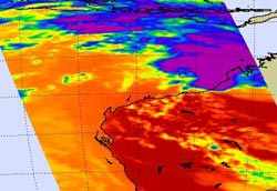
NASA\'s Aqua satellite captured an infrared image of Tropical Storm 10S on Jan. 25 at 05:53 UTC (12:53 a.m. EST). The image shows most of the coldest cloud tops (-63 Fahrenheit) and strongest thunderstorms over appear (in purple) over the Southern Indian Ocean, and some along the extreme northern coast of Western Australia. The red coloration further south is the heat of the land. Credit: NASA/JPL, Ed Olsen<br>
When Aqua passed over the Tropical Storm 10S on January 25 at 05:53 UTC (12:53 a.m. EST), the Atmospheric Infrared Sounder (AIRS) instrument captured an infrared image of the storm's clouds.
The image showed that most of the coldest cloud tops (-63 Fahrenheit/-52 Celsius) and strongest thunderstorms over appeared over the Southern Indian Ocean, and some along the extreme northern coast of Western Australia. The infrared image also showed the contrasting heat of the land.
A Cyclone Warning is current for coastal and island communities from Cape Leveque to Coral Bay. At 1500 UTC (10 a.m. EST) on January 25, Tropical Storm 10S had maximum sustained winds of 35 knots (40 mph / 64 km/hr). Tropical Storm 10S was located about 525 miles ENE of Learmonth, Australia near 17.4 South latitude and 121.8 East longitude. It was moving southwest near 15 knots (17 mph/27 km/hr). Waves along coastal areas could reach 10 feet, so beach erosion is likely, and low level flooding is possible. At 17:30 UTC (2:30 p.m. EST), moderate to heavy rains were moving toward Port Hedland, in advance of the center of Tropical Storm 10S.
TD 10S is moving southwest and is forecast to move parallel to the western coastline of Australia. The storm is expected to strengthen to hurricane force but not threaten land areas.
Updates on all tropical cyclones: www.nasa.gov/hurricane
Media Contact
All latest news from the category: Earth Sciences
Earth Sciences (also referred to as Geosciences), which deals with basic issues surrounding our planet, plays a vital role in the area of energy and raw materials supply.
Earth Sciences comprises subjects such as geology, geography, geological informatics, paleontology, mineralogy, petrography, crystallography, geophysics, geodesy, glaciology, cartography, photogrammetry, meteorology and seismology, early-warning systems, earthquake research and polar research.


Newest articles

Properties of new materials for microchips
… can now be measured well. Reseachers of Delft University of Technology demonstrated measuring performance properties of ultrathin silicon membranes. Making ever smaller and more powerful chips requires new ultrathin…

Floating solar’s potential
… to support sustainable development by addressing climate, water, and energy goals holistically. A new study published this week in Nature Energy raises the potential for floating solar photovoltaics (FPV)…

Skyrmions move at record speeds
… a step towards the computing of the future. An international research team led by scientists from the CNRS1 has discovered that the magnetic nanobubbles2 known as skyrmions can be…

