NASA imagery sees a reawakening of system 98A in the Arabian Sea
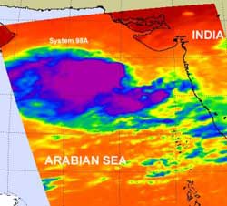
NASA's Aqua satellite AIRS instrument captured an infrared look at System 98A's cloud temperatures and thunderstorms on June 8 at 08:47 UTC (4:47 a.m. EDT) and saw a large area of strong convection (purple). Credit: Credit: NASA/JPL, Ed Olsen<br>
NASA's Atmospheric Infrared Sounder (AIRS) instrument onboard NASA's Aqua satellite captured an image on June 8 at 08:47 UTC (4:47 a.m. EDT) of the hundreds of thunderstorms that make up the low pressure area called System 98A. The low pressure area has now moved to the west-southwest and away from Mumbai, India. In fact, today it is located about 200 miles west-southwest of Mumbai near 17.2 North and 69.8 East.
It appears that the warm waters of the Arabian Sea, and the freedom from land areas has enabled the convection (rapidly rising air that forms the thunderstorms that power a tropical cyclone) to strengthen. AIRS infrared imagery today shows a very large area of high, cold thunderstorm cloud tops mostly on the southwestern side of the center of circulation. That area has temperatures as cold as or colder (it's a benchmark) than -63 Fahrenheit/-52 Celsius. Those cold temperatures in cloud tops mean they're very high in the troposphere and the thunderstorms have a lot of uplift. It also suggests that they're heavy rainmakers.
Despite stronger convection, infrared imagery also showed that the low level circulation center is partially exposed to outside winds. Another factor that's not enabling the low to strengthen into a tropical storm is the presence of dry air that was seen yesterday. Dry air is still present to the northwest of the low, and dry air saps moisture out of the air and suppresses thunderstorm development. That could help explain why most of the convection is in the southern side of the low.
System 98A is drifting slowly to the northwest, and according to the Joint Typhoon Warning Center, its maximum sustained winds are between 25 to 30 knots (29 to 34/46 to 55 kmh). The Joint Typhoon Warning Center gives System 98A a medium chance of strengthening into a tropical storm in the next 24 hours.
Media Contact
More Information:
http://www.nasa.govAll latest news from the category: Earth Sciences
Earth Sciences (also referred to as Geosciences), which deals with basic issues surrounding our planet, plays a vital role in the area of energy and raw materials supply.
Earth Sciences comprises subjects such as geology, geography, geological informatics, paleontology, mineralogy, petrography, crystallography, geophysics, geodesy, glaciology, cartography, photogrammetry, meteorology and seismology, early-warning systems, earthquake research and polar research.


Newest articles

Properties of new materials for microchips
… can now be measured well. Reseachers of Delft University of Technology demonstrated measuring performance properties of ultrathin silicon membranes. Making ever smaller and more powerful chips requires new ultrathin…

Floating solar’s potential
… to support sustainable development by addressing climate, water, and energy goals holistically. A new study published this week in Nature Energy raises the potential for floating solar photovoltaics (FPV)…

Skyrmions move at record speeds
… a step towards the computing of the future. An international research team led by scientists from the CNRS1 has discovered that the magnetic nanobubbles2 known as skyrmions can be…

