NASA Identifies Heavy Rainfall in South China Sea's Typhoon Utor
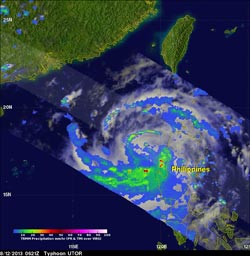
NASA's TRMM satellite captured rainfall rates of over 73mm/hr (~2.9 inches) happening in Typhoon Utor on Aug. 12 at 2:21 a.m. EDT as it was exiting the Philippines into the South China Sea. <br>Image Credit: SSAI/NASA, Hal Pierce <br>
NASA's Tropical Rainfall Measuring Mission or TRMM satellite passed over Utor on August 12, 2013 at 0621 UTC/2:21 a.m. EDT as it was exiting the Philippines into the South China Sea.
To form a complete picture of rainfall and cloud extent of Utor, TRMM's Microwave Imager (TMI) and Precipitation Radar (PR) data were added into a combination Infrared/Visible image from TRMM's Visible and InfraRed Scanner (VIRS) at NASA's Goddard Space Flight Center in Greenbelt, Md. TRMM PR found rain falling at a rate of over 73mm/~2.9 inches per hour in well-defined thunderstorm feeder bands extending over the South China Sea. TRMM PR also found that heavy rain in these lines of rain were returning radar reflectivity values greater than 50.5 dBZ.
When Utor was exiting the Philippines yesterday, Aug. 12, the storm's maximum sustained winds had fallen to 85 knots/97.8 mph/157.4 kph. By Aug. 13 at 1500 UTC/11 a.m. EDT the warm waters of the South China Sea had helped strengthen Utor, and maximum sustained winds were near 95 knots/109.3 mph/175.9 kph.
Utor's center is located near 19.5 north and 113.1 east, about 190 nautical miles south-southwestward of Hong Kong. Utor is moving to the west-northwestward at 6 knots/7 mph/11.1 kph. Utor's powerful winds are generating very high, and rough seas. Maximum significant wave heights were reported near 41 feet/12.5 meters.
Although Utor's winds had increased since yesterday, animated enhanced infrared satellite imagery today showed that the convective (rising air that forms the thunderstorms that make up the tropical cyclone) structure of the system has started to weaken, according to the Joint Typhoon Warning Center or JTWC. JTWC noted the convective bands had become shallower and weaker after 5 a.m. EDT today (Aug. 14). Infrared data also showed that the eye had become ragged in nature.
Typhoon Utor is predicted to move toward the west-northwest and make landfall in China tomorrow, Aug. 14 between Hainan Island and Hong Kong. More specifically, the forecast track from the Joint Typhoon Warning Center takes Utor's center somewhere between Zhanjiang and Maoming, Guangdong, China. The two cities are about 75 miles/121 kilometers apart.
The JTWC expects Utor to weaken after landfall and curve to the west-southwest over northern Vietnam, where it will begin to dissipate.
Text credit: Hal Pierce/Rob Gutro
SSAI/NASA Goddard Space Flight Center
Media Contact
All latest news from the category: Earth Sciences
Earth Sciences (also referred to as Geosciences), which deals with basic issues surrounding our planet, plays a vital role in the area of energy and raw materials supply.
Earth Sciences comprises subjects such as geology, geography, geological informatics, paleontology, mineralogy, petrography, crystallography, geophysics, geodesy, glaciology, cartography, photogrammetry, meteorology and seismology, early-warning systems, earthquake research and polar research.


Newest articles

Properties of new materials for microchips
… can now be measured well. Reseachers of Delft University of Technology demonstrated measuring performance properties of ultrathin silicon membranes. Making ever smaller and more powerful chips requires new ultrathin…

Floating solar’s potential
… to support sustainable development by addressing climate, water, and energy goals holistically. A new study published this week in Nature Energy raises the potential for floating solar photovoltaics (FPV)…

Skyrmions move at record speeds
… a step towards the computing of the future. An international research team led by scientists from the CNRS1 has discovered that the magnetic nanobubbles2 known as skyrmions can be…

