NASA gets a last look at Tropical Depression Enawo's final bow
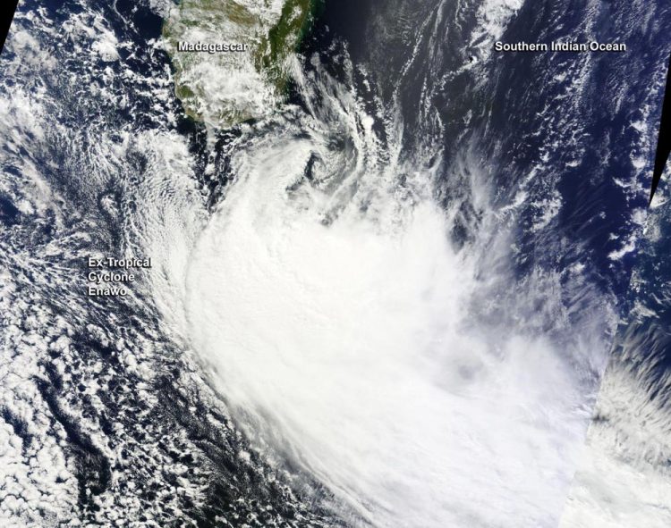
NASA's Terra satellite captured this visible image of Tropical Depression Enawo on March 10 at 0515 UTC (12:15 a.m. EST). Credits: NASA
Enawo regenerated off the southeastern coast of Madagascar on March 10 at 0000 UTC (Mar. 9 at 7 p.m. EST) when it was about 434 nautical miles (499 miles/ 804 km) southeast of Europa Island. Enawo's maximum sustained winds spun up to 45 knots (51.7 mph/83.3 kph) as the reborn storm moved to the south-southeast at 22 knots (25.3 mph/40.7 kph).
When NASA's Terra satellite flew over Tropical Depression Enawo on March 10 at 0515 UTC (12:15 a.m. EST) the Moderate Resolution Imaging Spectroradiometer or MODIS instrument took a visible light picture of the storm.
The image revealed that moderate to strong vertical wind shear had stretched out the clouds associated with the low pressure area. The bulk of the depression's clouds were pushed south of the center.
By 1500 UTC (10 a.m. EST), vertical wind shear battering the storm had weakened its maximum sustained winds to 30 knots (34.5 mph/55.5 kph).
It was located about 557 nautical miles (641 miles/1,032 km) southwest of St. Denis, La Reunion Island and was moving to the southeast at 13 knots (14.9 mph/24.0 kph). At that time, the Joint Typhoon Warning Center (JTWC) in Pearl Harbor, Hawaii said “Animated multispectral satellite imagery showed the low level circulation has unraveled and the associated convection has collapsed and dispersed due to high vertical wind shear.”
That statement marked the JTWC's final warning on Enawo as the system was being sheared apart in the Southern Indian Ocean.
Rob Gutro NASA's Goddard Space Flight Center
Media Contact
All latest news from the category: Earth Sciences
Earth Sciences (also referred to as Geosciences), which deals with basic issues surrounding our planet, plays a vital role in the area of energy and raw materials supply.
Earth Sciences comprises subjects such as geology, geography, geological informatics, paleontology, mineralogy, petrography, crystallography, geophysics, geodesy, glaciology, cartography, photogrammetry, meteorology and seismology, early-warning systems, earthquake research and polar research.


Newest articles

Zap Energy achieves 37-million-degree temperatures in a compact device
New publication reports record electron temperatures for a small-scale, sheared-flow-stabilized Z-pinch fusion device. In the nine decades since humans first produced fusion reactions, only a few fusion technologies have demonstrated…

Innovative microscopy demystifies metabolism of Alzheimer’s
Researchers at UC San Diego have deployed state-of-the art imaging techniques to discover the metabolism driving Alzheimer’s disease; results suggest new treatment strategies. Alzheimer’s disease causes significant problems with memory,…
A cause of immunodeficiency identified
After stroke and heart attack: Every year, between 250,000 and 300,000 people in Germany suffer from a stroke or heart attack. These patients suffer immune disturbances and are very frequently…

