NASA Finds Tropical Depression Yagi’s Strongest Side, Now Waning
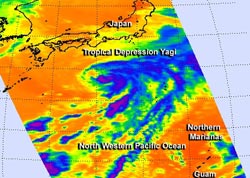
This infrared image of Tropical Depression Yagi was taken from the AIRS instrument aboard NASA’s Aqua satellite on June 11 at 12:05 a.m. EDT. The areas with the coldest cloud top temperatures and strongest thunderstorms (purple) were near -63F/-52C around the center and eastern quadrant of the storm. Those very cold cloud temperatures are indicative of heavy rainfall. Credit: NASA JPL/Ed Olsen<br>
When NASA’s Aqua satellite passed over Yagi on June 11 it was a tropical storm with strong thunderstorms on its eastern side. An infrared image of the storm was taken from the Atmospheric Infrared Sounder (AIRS) instrument aboard NASA’s Aqua satellite on June 11 at 12:05 a.m. EDT. The areas with the coldest cloud top temperatures and strongest thunderstorms were near -63F/-52C around the center and indicative of heavy rainfall.
Since June 11, an upper-level low pressure area from the north of Yagi has moved closer to the storm’s center, suppressing thunderstorm development. Animated infrared satellite imagery showed that the storm’s low-level center is now fully exposed to outside winds and has elongated. Whenever a storm loses its circulation and becomes elongated it weakens (like a tire going flat that can’t spin properly). There is no recognizable convection (rising air that forms thunderstorms that make up the tropical cyclone) around the storm’s center.
In addition to the upper-level low squelching the storm, Yagi has moved into cooler waters that do not support maintaining a tropical cyclone. Sea surface temperatures of at least 80F (26.6 C) are needed to keep a tropical cyclone going. The sea surface temperatures around Yagi are as cool as 223 Celsius, too cool to maintain the storm.
On June 12 at 1500 UTC (11 a.m. EDT) Tropical depression Yagi was spinning down in the northwestern Pacific Ocean. Yagi’s maximum sustained winds were down to 30 knots. It was centered near 31.2 north latitude and 138.9 east longitude, about 250 miles south of Yokosuka, Japan. Yagi is moving to the east-northeast at 8 knots.
According to the Joint Typhoon Warning Center (JTWC), the organization that forecasts storms in the northwestern Pacific, Yagi was still a “weakly symmetric warm-core system,” but it is expected to become a cold-core low pressure area by the end of June 12. JTWC forecasters expect Yagi to dissipate by June 13.
Text credit: Rob Gutro
NASA’s Goddard Space Flight Center
Media Contact
All latest news from the category: Earth Sciences
Earth Sciences (also referred to as Geosciences), which deals with basic issues surrounding our planet, plays a vital role in the area of energy and raw materials supply.
Earth Sciences comprises subjects such as geology, geography, geological informatics, paleontology, mineralogy, petrography, crystallography, geophysics, geodesy, glaciology, cartography, photogrammetry, meteorology and seismology, early-warning systems, earthquake research and polar research.


Newest articles

Machine learning algorithm reveals long-theorized glass phase in crystal
Scientists have found evidence of an elusive, glassy phase of matter that emerges when a crystal’s perfect internal pattern is disrupted. X-ray technology and machine learning converge to shed light…

Mapping plant functional diversity from space
HKU ecologists revolutionize ecosystem monitoring with novel field-satellite integration. An international team of researchers, led by Professor Jin WU from the School of Biological Sciences at The University of Hong…

Inverters with constant full load capability
…enable an increase in the performance of electric drives. Overheating components significantly limit the performance of drivetrains in electric vehicles. Inverters in particular are subject to a high thermal load,…

