NASA Eyes the Birth of Tropical Cyclone Haley
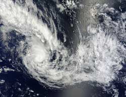
On Feb. 9 at 2020 UTC the MODIS instrument aboard NASA's Terra satellite captured this visible image of Tropical Cyclone Haley (14P) in the South Pacific Ocean. Credit: NASA Goddard MODIS Rapid Response Team <br>
On Feb. 9 at 2020 UTC (3:20 p.m. EST) the Moderate Resolution Imaging Spectroradiometer (MODIS) instrument aboard NASA's Terra satellite captured a visible image of System 93P (known in Fiji as 14F). The MODIS image showed a circular center of circulation with banding features, two things that indicated that the low pressure area was quickly organizing. The next day, the low became Tropical Storm Haley.
Tropical Cyclone Haley formed on Feb. 10 at 0300 UTC, about 325 nautical miles (374 miles 602 km) south-southwest of Bora Bora, Society Islands, French Polynesia, in the open waters of the South Pacific Ocean. Maximum sustained winds strengthened quickly to 45 knots (51.7 mph/83.3 kph). Soon after Haley intensified, infrared satellite imagery indicated that convection (rising air that forms thunderstorms that make up the storm) were already weakening around the center.
On Feb. 11 at 0300 UTC, the Joint Typhoon Warning Center issued its final advisory on Tropical Cyclone Haley. At that time, Haley's center was located near 24.8 south latitude and 150.0 west longitude, about 500 nautical miles (575.4 miles/926 km) southeast of Bora Bora, Society Islands. Haley was moving to the southeast at 11 knots (12.6 mph/20.3 kph). As a result of wind shear and cooler sea surface temperatures, Haley's maximum sustained winds had already dropped to 35 knots (40.2 mph/64.8 kph).
The forecasters at the Joint Typhoon Warning Center expect Haley to continue moving southeast as wind shear increases and sea surface temperatures become even cooler. Both of those factors are expected to dissipate Haley by Tuesday, Feb. 12.
Text Credit: Rob Gutro
NASA's Goddard Space Flight Center
Media Contact
All latest news from the category: Earth Sciences
Earth Sciences (also referred to as Geosciences), which deals with basic issues surrounding our planet, plays a vital role in the area of energy and raw materials supply.
Earth Sciences comprises subjects such as geology, geography, geological informatics, paleontology, mineralogy, petrography, crystallography, geophysics, geodesy, glaciology, cartography, photogrammetry, meteorology and seismology, early-warning systems, earthquake research and polar research.


Newest articles

Silicon Carbide Innovation Alliance to drive industrial-scale semiconductor work
Known for its ability to withstand extreme environments and high voltages, silicon carbide (SiC) is a semiconducting material made up of silicon and carbon atoms arranged into crystals that is…

New SPECT/CT technique shows impressive biomarker identification
…offers increased access for prostate cancer patients. A novel SPECT/CT acquisition method can accurately detect radiopharmaceutical biodistribution in a convenient manner for prostate cancer patients, opening the door for more…

How 3D printers can give robots a soft touch
Soft skin coverings and touch sensors have emerged as a promising feature for robots that are both safer and more intuitive for human interaction, but they are expensive and difficult…

