NASA examines powerful Tropical Cyclone Emeraude's winds, clouds
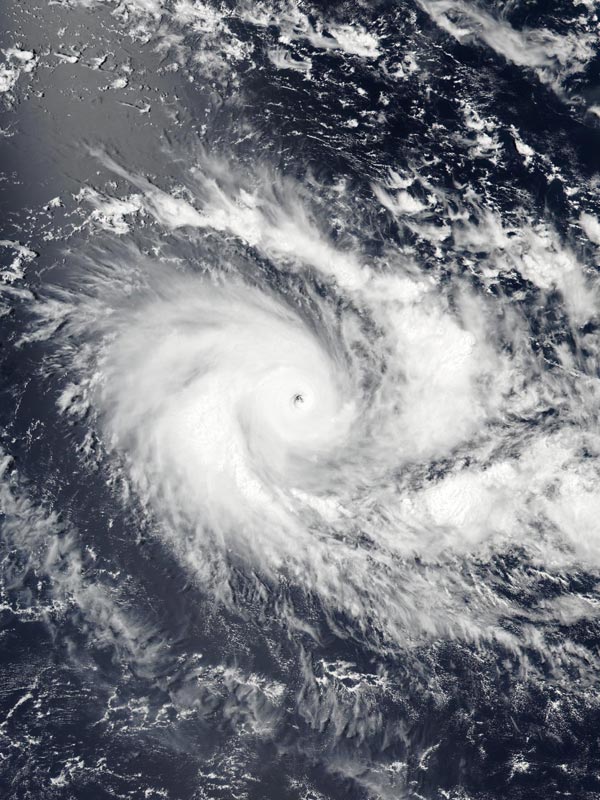
NASA-NOAA's Suomi NPP satellite captured a visible image of Tropical Cyclone Emeraude at hurricane strength on March 17, showing a small eye in the center of circulation. Credits: NASA/NOAA
Emeraude is in the southern part of the Indian Ocean over 1,000 km from the nearest land area. It is roughly south of Sri Lanka and west of Java.
The Atmospheric Infrared Sounder or AIRS instrument that flies aboard NASA's Aqua satellite provided infrared temperature data on Emeraude on March 16 sat 07:59 UTC (3:59 a.m. EDT).
AIRS revealed bands of thunderstorms wrapping into the center of circulation from the east and southwest had cloud top temperatures as cold as minus 63 Fahrenheit/minus 53 Celsius. Temperatures that cold indicated strong storms high into the troposphere with the potential to generate heavy rain.
NASA's RapidScat instrument that flies aboard the International Space Station measures Earth's ocean surface wind speed and direction over open waters. When the ISS flew over Emeraude on March 16 RapidScat saw strongest sustained winds approaching 30 meters per second (67.1 mph/108 kph) and the storm was intensifying rapidly.
Emeraude intensified from a tropical storm on March 16 into a major hurricane by March 17.
The Visible Infrared Imaging Radiometer Suite (VIIRS) instrument aboard NASA-NOAA's Suomi NPP satellite captured a visible image of Tropical Cyclone Emeraude at hurricane strength on March 17 at 0755 UTC (3:55 a.m. EDT) showing a small 14 nautical-mile-wide (16.1 miles/25.9 km) eye in the center of circulation. At the time Suomi NPP passed over Emeraude, it was a Category 4 hurricane on the Saffir-Simpson Wind Scale.
At 0900 UTC (5 a.m. EST) on March 17, 2016 Tropical Cyclone Emeraude's maximum sustained winds had increased to 125 knots (143.8 mph/231.5 kph) and still intensifying. It was located near 10.4 degrees south latitude and 84.0 degrees east longitude, about 710 nautical miles (817 miles/1,316 km) east-southeast of Diego Garcia. Emeraude was moving slowing to the west-northwest at 2 knots (2.3 mph/3.7 kph).
By March 17, wind data showed tropical-storm-force winds were occurring up to 90 nautical miles (103.6 miles/166 km) from the center and hurricane-force winds within 30 nautical miles (34.5 miles/55.5 km) of the eye.
The Joint Typhoon Warning Center expects Emeraude's maximum sustained winds to peak around 135 knots (155.4 mph/250 kph) on March 18 before a weakening trend begins. The storm is also expected turn east-southeast before turning southwest on March 21 all while remaining over open waters of the Southern Indian Ocean.
Media Contact
All latest news from the category: Earth Sciences
Earth Sciences (also referred to as Geosciences), which deals with basic issues surrounding our planet, plays a vital role in the area of energy and raw materials supply.
Earth Sciences comprises subjects such as geology, geography, geological informatics, paleontology, mineralogy, petrography, crystallography, geophysics, geodesy, glaciology, cartography, photogrammetry, meteorology and seismology, early-warning systems, earthquake research and polar research.


Newest articles

Properties of new materials for microchips
… can now be measured well. Reseachers of Delft University of Technology demonstrated measuring performance properties of ultrathin silicon membranes. Making ever smaller and more powerful chips requires new ultrathin…

Floating solar’s potential
… to support sustainable development by addressing climate, water, and energy goals holistically. A new study published this week in Nature Energy raises the potential for floating solar photovoltaics (FPV)…

Skyrmions move at record speeds
… a step towards the computing of the future. An international research team led by scientists from the CNRS1 has discovered that the magnetic nanobubbles2 known as skyrmions can be…

