NASA covers Super Typhoon Maysak's rainfall, winds, clouds, eye
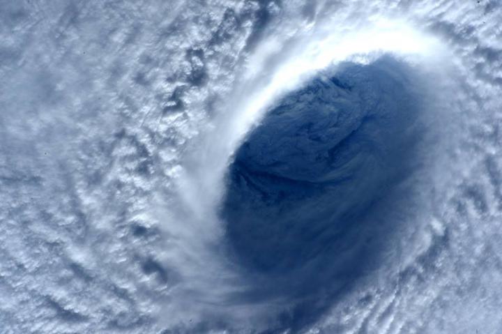
This close up photo of Super Typhoon Maysak's eye was taken by Terry Virts aboard the International Space Station on April 1, 2015. Image Credit: NASA/Terry Virts
On April 1 at 01:35 UTC (March 31 at 9:35 p.m. EDT), the Moderate Resolution Imaging Spectroradiometer or MODIS instrument aboard NASA's Terra satellite captured a stunning view of Super Typhoon Maysak in the Northwestern Pacific Ocean.
The MODIS image clearly showed its eye and bands of powerful thunderstorms circling the eye, and wrapping into it from the east and west.
From the International Space Station, astronaut Terry Virts photographed Super Typhoon Maysak's 15 nautical-mile wide eye using a zoom lens on April 1, 2015.
The Global Precipitation Measurement or GPM core observatory's Microwave Imager (GMI) revealed that Maysak was dropping rain at a rate of over 70 mm (2.8 inches) per hour northwest of a well-defined eye on April 1 at 12:15 UTC (8:15 a.m. EDT). The 12:11 UTC (8:11 a.m. EDT) GPM microwave image also showed the weakening of the deep convection on the southern edge of the storm.
Super typhoon Maysak's winds were near 130 knots (~150 mph) and the storm was north of Palau in the western Pacific Ocean when the Global Precipitation Measurement of GPM core observatory satellite flew overhead on April 1, 2015 at 1215 UTC (8:15 a.m. EDT). GPM's Microwave Imager (GMI) revealed that Maysak was dropping rain at a rate of over 70 mm (2.8 inches) per hour northwest of a well-defined eye.
On April 1 at 1500 UTC (11 a.m. EDT) Super Typhoon Maysak, known in the Philippines as Chedeng, was centered near 11.6 north latitude and 135.6 east longitude, about 194 nautical miles (223 miles/359.3 km) northwest of Yap.
Maysak's maximum sustained winds were near 130 knots (149.6 mph/ 240.8 kph) with higher gusts. Maysak is a Category 4 hurricane on the Saffir-Simpson Wind Scale. The super typhoon was moving to the west-northwest at 10 knots (11.5 mph/18.5 kph) and generating 44-foot-high seas (13.4 meters).
The Joint Typhoon Warning Center (JTWC) noted that Maysak appears to be “weakening slightly, as can be seen by the increase in dry air entrainment (moving into the system) seen in the water vapor and total perceptible water loops (animated imagery).”
The JTWC forecast calls for Maysak to move northwest toward the Central Luzon Region of the Philippines. The storm is not expected to intensify further and begin weakening in the next day as vertical wind shear increases. JTWC is forecasting a landfall in Central Luzon on April 4.
###
Currently, there are no warnings posted in the Philippines, but residents should make preparations for the storm's approach. For updates on warnings and watches, visit: http://www.
Media Contact
All latest news from the category: Earth Sciences
Earth Sciences (also referred to as Geosciences), which deals with basic issues surrounding our planet, plays a vital role in the area of energy and raw materials supply.
Earth Sciences comprises subjects such as geology, geography, geological informatics, paleontology, mineralogy, petrography, crystallography, geophysics, geodesy, glaciology, cartography, photogrammetry, meteorology and seismology, early-warning systems, earthquake research and polar research.


Newest articles

“Nanostitches” enable lighter and tougher composite materials
In research that may lead to next-generation airplanes and spacecraft, MIT engineers used carbon nanotubes to prevent cracking in multilayered composites. To save on fuel and reduce aircraft emissions, engineers…

Trash to treasure
Researchers turn metal waste into catalyst for hydrogen. Scientists have found a way to transform metal waste into a highly efficient catalyst to make hydrogen from water, a discovery that…

Real-time detection of infectious disease viruses
… by searching for molecular fingerprinting. A research team consisting of Professor Kyoung-Duck Park and Taeyoung Moon and Huitae Joo, PhD candidates, from the Department of Physics at Pohang University…

