NASA catches system 92W become fifth NW Pacific tropical depression
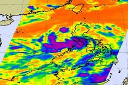
This image of Tropical Depression 05W in the Northwestern Pacific June 8 at 1741 UTC (1:41 p.m. EDT) from the NASA AIRS instrument shows strong thunderstorms (purple) over the southern side of the circulation center. Credit: NASA JPL/Ed Olsen<br>
Tropical Depression 05W (TD05W) also known as Dodong in the Philippines was caught by infrared NASA satellite imagery on June 8 at 1741 UTC (1:41 p.m. EDT).
The infrared data showed some powerful thunderstorms with very cold cloud top temperatures near the threshold of AIRS data of -63 Fahrenheit and -52 Celsius. That indicates the coldest, strongest thunderstorms within the tropical depression. Some of the strongest thunderstorms at that time were over western Luzon and stretched out over the South China Sea.
AIRS microwave imagery today showed that the banding of thunderstorms around the southern edge of the depression had the strongest storms. The storm's convection has decreased today. The decrease in convection is because of an upper-level trough (elongated area) of low pressure to the north that is preventing convection from occurring on the storm's northern side.
At 1500 UTC on June 9, TD05W was about 190 miles northwest of Manila, Philippines near 16.7 North and 118.4 East. It was moving to the north-northwest near 12 knots and had maximum sustained winds near 25 knots with higher gusts. It is now moving toward southern China and is expected to intensify into a tropical storm.
Warnings remain posted in the Philippines as TD05W continues pulling away.
NASA's Hurricane page: www.nasa.gov/hurricane
Media Contact
More Information:
http://www.nasa.govAll latest news from the category: Earth Sciences
Earth Sciences (also referred to as Geosciences), which deals with basic issues surrounding our planet, plays a vital role in the area of energy and raw materials supply.
Earth Sciences comprises subjects such as geology, geography, geological informatics, paleontology, mineralogy, petrography, crystallography, geophysics, geodesy, glaciology, cartography, photogrammetry, meteorology and seismology, early-warning systems, earthquake research and polar research.


Newest articles

Machine learning algorithm reveals long-theorized glass phase in crystal
Scientists have found evidence of an elusive, glassy phase of matter that emerges when a crystal’s perfect internal pattern is disrupted. X-ray technology and machine learning converge to shed light…

Mapping plant functional diversity from space
HKU ecologists revolutionize ecosystem monitoring with novel field-satellite integration. An international team of researchers, led by Professor Jin WU from the School of Biological Sciences at The University of Hong…

Inverters with constant full load capability
…enable an increase in the performance of electric drives. Overheating components significantly limit the performance of drivetrains in electric vehicles. Inverters in particular are subject to a high thermal load,…

