NASA and NOAA Satellites Analyze Category 4 Hurricane Cristina
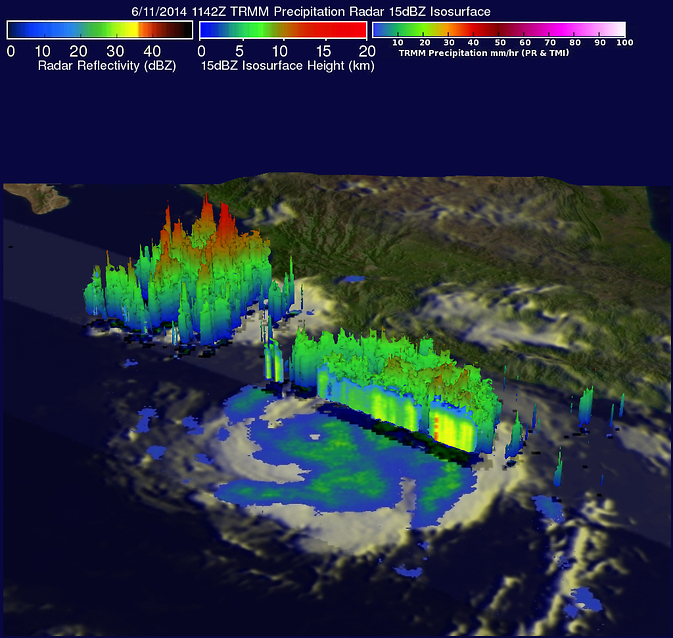
On June 11, NASA's TRMM satellite found rain falling at a rate of over 74.4 mm/2.9 inches per hour in a strong feeder band east of Cristina's eye. Another area of thunderstorms west of Puerto Vallarta had heavy rain and thunderstorm tops reaching heights of about 16.5km (about 10.2 miles). Image Credit: NASA/SSAI, Hal Pierce
This morning, June 12, at 1200 UTC (8 a.m. EDT), NOAA's GOES-West satellite provided an infrared image of Hurricane Cristina that showed a very clear, distinct eye. Although Cristina's center is over open ocean, this intense hurricane is causing rough surf along the west coast of Mexico today. The National Hurricane Center (NHC) noted that swells continue to affect southwestern Mexico, and could cause life-threatening surf and riptide conditions.
NHC noted in the discussion at 11 a.m. EDT (8 a.m. PDT) that Cristina has gone through an extraordinary, but not unprecedented, phase of rapid intensification during the past 24 hours, with its maximum winds increasing by about 65 knots (74.8 mph/120.4 kph) since that time on June 11.
When the TRMM satellite flew over Cristina on June 11, 2014 at 1142 UTC (4:42 a.m. PDT) it was a hurricane. A rainfall analysis that used data from TRMM's Microwave Imager (TMI) and Precipitation Radar (PR) instruments was overlaid on an enhanced infrared image received by NOAA's GOES-East satellite at 1145 UTC (7:45 a.m. EDT) to provide a complete picture of the hurricane's cloud extent and rainfall rates.
The TRMM TMI data clearly revealed that an eye had developed indicating that Cristina was definitely a hurricane. TRMM PR found that rain was falling at a rate of over 74.4 mm (2.9 inches) per hour in a strong feeder band east if Cristina's eye. Another smaller area of strong convective thunderstorms west of Puerto Vallarta, Mexico was also found to contain very heavy rainfall with the tallest thunderstorm tops reaching heights of about 16.5km (10.2 miles).
Later on June 11, at 19:59 UTC (3:59 p.m. EDT) when NASA's Aqua satellite passed over Hurricane Christina as it was rapidly intensifying, the Atmospheric Infrared Sounder (AIRS) instrument gathered infrared data on the cloud top temperatures of the storm. By early morning on June 12, Cristina had a circular central dense overcast with very cold cloud tops near -80C (-112F).
At 11 a.m. EDT (8 a.m. PDT) on June 12, Hurricane Cristina's maximum sustained wind were near 150 mph (240 kph). Cristina was about 250 miles (400 km) southwest of Manzanillo, Mexico, near latitude 16.6 north and longitude 107.1 west. Cristina was moving toward the west-northwest near 8 mph (13 kph) and a northwestward to west-northwestward motion is expected through Saturday morning (June 14).The estimated minimum central pressure is 935 millibars.
The NHC said that light vertical wind shear and a deep warm ocean should allow Cristina to maintain major hurricane strength for another 36 hours.
Text credit: Rob Gutro
NASA's Goddard Space Flight Center
Media Contact
More Information:
http://www.nasa.gov/content/goddard/cristina-eastern-pacific-ocean/All latest news from the category: Earth Sciences
Earth Sciences (also referred to as Geosciences), which deals with basic issues surrounding our planet, plays a vital role in the area of energy and raw materials supply.
Earth Sciences comprises subjects such as geology, geography, geological informatics, paleontology, mineralogy, petrography, crystallography, geophysics, geodesy, glaciology, cartography, photogrammetry, meteorology and seismology, early-warning systems, earthquake research and polar research.


Newest articles

Security vulnerability in browser interface
… allows computer access via graphics card. Researchers at Graz University of Technology were successful with three different side-channel attacks on graphics cards via the WebGPU browser interface. The attacks…

A closer look at mechanochemistry
Ferdi Schüth and his team at the Max Planck Institut für Kohlenforschung in Mülheim/Germany have been studying the phenomena of mechanochemistry for several years. But what actually happens at the…

Severe Vulnerabilities Discovered in Software to Protect Internet Routing
A research team from the National Research Center for Applied Cybersecurity ATHENE led by Prof. Dr. Haya Schulmann has uncovered 18 vulnerabilities in crucial software components of Resource Public Key…

