NASA AIRS Satellite instrument sees Tropical Depression 14W form
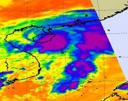
The Atmospheric Infrared Sounder (AIRS) instrument on NASA\'s Aqua satellite revealed a concentrated area of thunderstorms and strong convection (purple) around TD14W\'s center (directly over Hainan Island, China) in the eastern quadrant of the storm. Cloud top temperatures were as cold as -60 Fahrenheit in the purple areas. The convection in the east is a result of westerly wind shear blowing the convection and thunderstorms away from the storm\'s center. Credit: NASA/JPL, Ed Olsen<br>
NASA's Aqua satellite flew over Tropical Depression 14W (TD14W) today, October 5 at 06:05 UTC (2:05 a.m. EDT). Infrared imagery from the Atmospheric Infrared Sounder (AIRS) instrument onboard the Aqua satellite revealed a concentrated area of thunderstorms and strong convection (rapidly rising air that forms thunderstorms that power a tropical cyclone) around TD14W's center in the eastern quadrant of the storm. That convection in the east is a result of westerly wind shear blowing the convection and thunderstorms away from the storm's center.
Infrared imagery also indicated that those storms are weakening, because the cloud tops are now warming from previous imagery. Very cold thunderstorm cloud tops (colder than -60 Fahrenheit) indicate strong thunderstorms, very high into the troposphere, that likely have heavy rain associated with them. When AIRS detects that cloud top temperatures have warmed, it means the heights of the thunderstorms has dropped, meaning there's not as much power or uplift in the convection.
AIRS imagery also showed a poorly-defined low-level center of circulation in TD14W, and some of that deep convection (or thunderstorms) are pushed away from the eastern side of the center. That indicates wind shear (winds that buffet a storm and push it apart). When a storm doesn't stack up, and when part of the storm is displaced from the rest of it, it loses its organization and punch. That's what wind shear does, and is doing to TD14W and that wind shear is blowing at about 28 mph!
At 5 a.m. EDT, October 5, Tropical Depression 14W had maximum sustained winds near 34 mph. It was located over Hainan Island near 19.5 North and 109.4 East. Its winds were creating 9-foot high seas. TD14W was moving north at 6 mph. It is expected to make a turn to the north-northeast, make a brief landfall in the mainland of southern China. Once there, it is forecast to move east, then east-southeast, making a half-circle and head toward the eastern end of Hainan Island and dissipate.
Media Contact
More Information:
http://www.nasa.govAll latest news from the category: Earth Sciences
Earth Sciences (also referred to as Geosciences), which deals with basic issues surrounding our planet, plays a vital role in the area of energy and raw materials supply.
Earth Sciences comprises subjects such as geology, geography, geological informatics, paleontology, mineralogy, petrography, crystallography, geophysics, geodesy, glaciology, cartography, photogrammetry, meteorology and seismology, early-warning systems, earthquake research and polar research.


Newest articles

Superradiant atoms could push the boundaries of how precisely time can be measured
Superradiant atoms can help us measure time more precisely than ever. In a new study, researchers from the University of Copenhagen present a new method for measuring the time interval,…

Ion thermoelectric conversion devices for near room temperature
The electrode sheet of the thermoelectric device consists of ionic hydrogel, which is sandwiched between the electrodes to form, and the Prussian blue on the electrode undergoes a redox reaction…

Zap Energy achieves 37-million-degree temperatures in a compact device
New publication reports record electron temperatures for a small-scale, sheared-flow-stabilized Z-pinch fusion device. In the nine decades since humans first produced fusion reactions, only a few fusion technologies have demonstrated…

