NASA's Various Views of Tropical Storm Dorian
This night-time, infrared image of Tropical Storm Dorian was taken from the VIIRS instrument aboard the Suomi-NPP satellite on July 25 at 03:52 UTC. The red and purple areas are very high thunderstorms. <br>Image Credit: UWI-Madison/NASA-NOAA<br>
A Suomi-NPP Satellite View
NASA-NOAA's Suomi-NPP satellite flew over Tropical Storm Dorian on July 25 at 03:52 UTC (July 24 at 11:52 p.m. EDT). At that time the Visible Infrared Imager Radiometer Suite or VIIRS instrument that flies aboard the satellite captured a night-time, infrared image of Tropical Storm Dorian. VIIRS data showed that the thunderstorms that surround the center of circulation were as cold as 195 to 200 kelvin. Those frigid temperatures indicate very high thunderstorms shooting to the top of the troposphere (lowest layer of atmosphere).
VIIRS, a scanning radiometer, collects visible and infrared imagery and radiometric measurements. VIIRS data is used to measure cloud and aerosol properties, ocean color, sea and land surface temperature, ice motion and temperature, fires, and Earth's albedo.
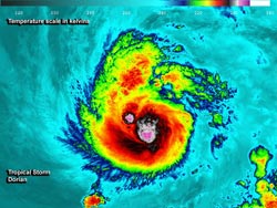
An Aqua Satellite View
The Atmospheric Infrared Sounder or AIRS instrument also captures infrared data and captured data on Dorian hours after VIIRS. AIRS flies aboard NASA's Aqua satellite and flew over Dorian on July 25 at 15:59 UTC (11:59 a.m. EDT). AIRS data showed that Dorian maintained strong thunderstorms around its center. AIRS also showed an extended band of fragmented thunderstorms wrapping into Dorian's center from the south and southwest.
AIRS data also showed that Dorian had moved back into warmer sea surface temperatures between 300 (80F/26.8C) and 310 Kelvin (98.3F/36.8C).
TRMM Satellite View
When NASA and the Japan Space Agency's Tropical Rainfall Measuring Mission or TRMM satellite passed over Dorian on July 26 at 01:39 UTC (9:39 p.m. EDT on July 25), the instruments aboard measured the rainfall rates occurring within the storm. Mostly light to moderate rainfall was found near Dorian's center of circulation by TRMM's Microwave Imager (TMI) and Precipitation Radar (PR) instruments. TRMM imagery is created at NASA's Goddard Space Flight Center in Greenbelt, Md. where TRMM precipitation data is placed atop a visible/infrared image from TRMM's Visible and InfraRed Scanner to form a complete picture.
Where is Dorian?[
At 5 a.m. EDT (0900 UTC) on Friday, July 26, Dorian's maximum sustained winds had slowed to 50 mph (85 kph). The National Hurricane Center or NHC noted that Dorian has become less organized. Dorian was centered near 17.1 north latitude and 41.5 west longitude, about 1,425 miles (2,290 km) east of the Northern Leeward Islands. Dorian is moving to the west-northwest at 20 mph (32 kph). There were no warnings or watches in effect as of 5 a.m. EDT.
NHC noted that Dorian's disorganization is possibly due to a combination of southwesterly vertical wind shear and mid to upper-level dry air seen in water vapor imagery.
As the AIRS data showed on July 25, the convective area (showers and thunderstorms) has become elongated from north to south.
Dorian is expected to continue moving west-northwest and in 4 or 5 days (by Monday, July 29); NOAA forecasts take the storm over Hispaniola.
Text credit: Rob Gutro
NASA's Goddard Space Flight Center
Media Contact
All latest news from the category: Earth Sciences
Earth Sciences (also referred to as Geosciences), which deals with basic issues surrounding our planet, plays a vital role in the area of energy and raw materials supply.
Earth Sciences comprises subjects such as geology, geography, geological informatics, paleontology, mineralogy, petrography, crystallography, geophysics, geodesy, glaciology, cartography, photogrammetry, meteorology and seismology, early-warning systems, earthquake research and polar research.


Newest articles

Properties of new materials for microchips
… can now be measured well. Reseachers of Delft University of Technology demonstrated measuring performance properties of ultrathin silicon membranes. Making ever smaller and more powerful chips requires new ultrathin…

Floating solar’s potential
… to support sustainable development by addressing climate, water, and energy goals holistically. A new study published this week in Nature Energy raises the potential for floating solar photovoltaics (FPV)…

Skyrmions move at record speeds
… a step towards the computing of the future. An international research team led by scientists from the CNRS1 has discovered that the magnetic nanobubbles2 known as skyrmions can be…

