NASA's TRMM Satellite sees Typhoon Roke intensify rapidly before landfall in Japan
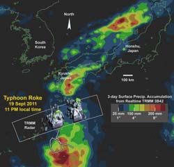
This large-scale image provides context for the 3D radar data (in gray) by showing the three-day surface rainfall accumulation (rainbow colors) along the track of the storm (gray line). Also shown is the significant rainfall accumulation (over 200 mm or ~8 inches) over the Japanese Island of Kyushu to the north of Typhoon Roke. Credit: Credit: NASA/TRMM/Owen Kelley<br>
Typhoon Roke followed a looping path for five days while maintaining tropical-storm strength prior to intensifying to typhoon-strength at 12 UTC (8 a.m. EDT) on September 19, 2011.
When the TRMM satellite flew over Typhoon Roke, it was in the process of rapidly intensifying from a Category 1 to 3 storm on the Saffir-Simpson scale (that measures hurricane/typhoon intensity). Owen Kelley of the TRMM team at NASA's Goddard Space Flight Center in Greenbelt, Md. created a large-scale image that provides context for 3-D radar data by showing the three-day surface rainfall accumulation along the track of the storm. The image also showed significant rainfall accumulation (over 200 mm or ~8 inches) over the Japanese Island of Kyushu to the north of Typhoon Roke.
This rain system continued to interact with Typhoon Roke in the subsequent 24 hours as Typhoon Roke continued moving north toward Japan's largest Island, Honshu.
The second image Kelley created zooms into the inner core of Typhoon Roke during a period of rapid intensification, seen by the TRMM satellite at 1351 UTC (9:51 a.m. EDT) on September 19, 2011.
That image showed cloud-top temperatures seen by the infrared instrument on the TRMM satellite and revealed where clouds were shallow, where they reach above the freezing level, and powerful thunderstorms that approached the tropopause indicating vigorous convection (rapidly rising air that form thunderstorms that power a tropical cyclone).
By creating an image in 3-D precipitation, becomes visible in the storm clouds. The 3-D image depicted rainfall and cloud height. The 3-D image was color coded where green tinting indicated precipitation reaching an altitude of 8.5 km (5.2 miles) and yellow tinting indicates an altitude of 11 km (6.8 miles). These altitudes are far above the freezing level that is typically near 5 km (3.1 miles) altitude in the tropics. When air rises more than a kilometer or so the freezing level, any moisture that condenses is likely to form ice hydrometeors instead of liquid hydrometeors and thereby release additional latent heat that may help fuel the storm.
This particular overflight of Typhoon Roke showed a remarkably well-organized circular eyewall especially for a typhoon that was classified at merely tropical-storm strength earlier the same day. However, other aspects of the TRMM radar data suggest modest intensity. Specifically, there is almost no radar reflectivity above 45 dBZ, and the inner volume of >42 dBZ is very small in the circular eyewall. A larger volume of strong reflectivity would indicate the formation of large ice hydrometeors or extremely heavy liquid precipitation. Either event would be evidence of very vigorous updrafts. Also, there was a complete absence of lightning flashes in either the eyewall or in the rainband to the east of the eyewall, based on observations by the TRMM Lightning Imaging System (LIS).
TRMM is managed by both NASA and the Japanese Space Agency, JAXA.
By 11:18 a.m. EDT (15:18 UTC) on Sept. 21, the southern edge of Roke was passing over Tokyo, while the northern extent stretched past Sapporo far to the north.
The Japan Meteorological Agency reported sustained winds of 103 mph (167 kph) and heavy rainfall in Japan's Tokai and Kanto regions earlier today. News reports have attributed four deaths to the storm and noted that rainfall had occurred at 2 inches (50 millimeters) per hour, confirming the data from the TRMM satellite. Roke is expected to re-emerge over water and transition into an extra-tropical storm later today.
Media Contact
More Information:
http://www.nasa.govAll latest news from the category: Earth Sciences
Earth Sciences (also referred to as Geosciences), which deals with basic issues surrounding our planet, plays a vital role in the area of energy and raw materials supply.
Earth Sciences comprises subjects such as geology, geography, geological informatics, paleontology, mineralogy, petrography, crystallography, geophysics, geodesy, glaciology, cartography, photogrammetry, meteorology and seismology, early-warning systems, earthquake research and polar research.


Newest articles

Properties of new materials for microchips
… can now be measured well. Reseachers of Delft University of Technology demonstrated measuring performance properties of ultrathin silicon membranes. Making ever smaller and more powerful chips requires new ultrathin…

Floating solar’s potential
… to support sustainable development by addressing climate, water, and energy goals holistically. A new study published this week in Nature Energy raises the potential for floating solar photovoltaics (FPV)…

Skyrmions move at record speeds
… a step towards the computing of the future. An international research team led by scientists from the CNRS1 has discovered that the magnetic nanobubbles2 known as skyrmions can be…

