NASA's TRMM satellite sees newborn Tropical Storm Pakhar's heavy rain
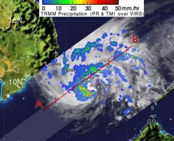
NASA's TRMM satellite measured rainfall rates in Tropical Storm Pakhar on March 29 at 1123 UTC (7:23 a.m. EDT).Light to moderate rainfall is depicted in blue and green, falling at a rate between .78 to 1.57 inches (20 to 40 mm) per hour. Heavy rainfall is seen in red, and is falling at 2 inches/50 mm per hour. Credit: SSAI/NASA, Hal Pierce<br>
NASA's Tropical Rainfall Measuring Mission (TRMM) satellite passed over Pakhar on March 29, and saw that it was generating mostly light to moderate rainfall around the entire system, with areas of heavy rain in the southwestern and northeastern quadrants.
Light to moderate rainfall rates were between .78 to 1.57 inches (20 to 40 mm) per hour and heavy rain was falling at a rate of 2 inches/50 mm per hour. The banding of thunderstorms has continued to consolidate and strengthen since March 28, which accounts for the cyclone's increase in strength.
On March 29 at 1500 UTC (11 a.m. EDT) Pakhar's maximum sustained winds virtually exploded from 35 knots (40.2 mph/64.8 kph) to 60 knots (69 mph/111 kph) within 12 hours because it is in an environment with lower wind shear and warm sea surface temperatures.
Pakhar is centered near 10.0 North and 111.6 East, about 300 nautical miles east of Ho Chi Minh City, Vietnam. It is moving to the west-northwest near 3 knots (3.4 mph/5.5 kph).
Forecasters at the Joint Typhoon Warning Center expect Pakhar to make landfall in central Vietnam, north of Ho Chi Minh City on March 31. Residents should prepare for rough surf along beaches, gusty winds and heavy rainfall.
Media Contact
More Information:
http://www.nasa.govAll latest news from the category: Earth Sciences
Earth Sciences (also referred to as Geosciences), which deals with basic issues surrounding our planet, plays a vital role in the area of energy and raw materials supply.
Earth Sciences comprises subjects such as geology, geography, geological informatics, paleontology, mineralogy, petrography, crystallography, geophysics, geodesy, glaciology, cartography, photogrammetry, meteorology and seismology, early-warning systems, earthquake research and polar research.


Newest articles

Silicon Carbide Innovation Alliance to drive industrial-scale semiconductor work
Known for its ability to withstand extreme environments and high voltages, silicon carbide (SiC) is a semiconducting material made up of silicon and carbon atoms arranged into crystals that is…

New SPECT/CT technique shows impressive biomarker identification
…offers increased access for prostate cancer patients. A novel SPECT/CT acquisition method can accurately detect radiopharmaceutical biodistribution in a convenient manner for prostate cancer patients, opening the door for more…

How 3D printers can give robots a soft touch
Soft skin coverings and touch sensors have emerged as a promising feature for robots that are both safer and more intuitive for human interaction, but they are expensive and difficult…

