NASA's TRMM Satellite Sees Hot Towers in Cyclone Koji
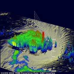
TRMM data from the flight over tropical storm Koji are shown in the 3-D image above. Those data reveal that an eye hadn't formed but powerful storm towers around KOJI's center were reaching heights of almost 15km (~9.3 miles).<br>Credit: NASA/SSAI, Hal Pierce <br>
The Tropical Rainfall Measuring Mission (TRMM) satellite passed directly above an intensifying tropical storm in the South Indian Ocean called Koji on March 8, 2012 at 2053 UTC (3:53 p.m. EST). A rainfall analysis was made from TRMM Microwave Imager (TMI) and Precipitation Radar (PR) data. Those TRMM data reveal that Koji was getting organized with bands of heavy rainfall spiraling into the storm's center.
One of its most important features of TRMM's Precipitation Radar (PR) instrument is its ability to provide three dimensional profiles of precipitation from the surface up to a height of about 20km (12 mile). PR data from the flight over tropical storm Koji are shown in the 3-D image above. Those data reveal that an eye hadn't formed but powerful storm towers around KOJI's center were reaching heights of almost 15 km (~9.3 miles).
On March 8, 2012 at 0900 UTC (4 a.m. EST), Tropical Storm Koji had maximum sustained winds near 55 knots (63.2 mph/102 kph). It was located near 17.1 South and 86.1 East, about 1000 miles southeast of Diego Garcia and moving to the west at 12 knots (13.8 mph/22.2 kph).
Koji has been predicted to increase in intensity and reach hurricane force with peak winds of 70kts (~80 mph) on March 8, 2012. Koji is predicted to remain at hurricane force for only one day and then weaken while traveling southwestward of the open waters of the South Indian Ocean.
Text Credit: Hal Pierce
SSAI/NASA's Goddard Space Flight Center, Greenbelt, Md.
Media Contact
All latest news from the category: Earth Sciences
Earth Sciences (also referred to as Geosciences), which deals with basic issues surrounding our planet, plays a vital role in the area of energy and raw materials supply.
Earth Sciences comprises subjects such as geology, geography, geological informatics, paleontology, mineralogy, petrography, crystallography, geophysics, geodesy, glaciology, cartography, photogrammetry, meteorology and seismology, early-warning systems, earthquake research and polar research.


Newest articles

“Nanostitches” enable lighter and tougher composite materials
In research that may lead to next-generation airplanes and spacecraft, MIT engineers used carbon nanotubes to prevent cracking in multilayered composites. To save on fuel and reduce aircraft emissions, engineers…

Trash to treasure
Researchers turn metal waste into catalyst for hydrogen. Scientists have found a way to transform metal waste into a highly efficient catalyst to make hydrogen from water, a discovery that…

Real-time detection of infectious disease viruses
… by searching for molecular fingerprinting. A research team consisting of Professor Kyoung-Duck Park and Taeyoung Moon and Huitae Joo, PhD candidates, from the Department of Physics at Pohang University…

