NASA's TRMM Satellite Measures Flooding Rains from Australia Monsoon
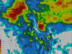
TRMM satellite rainfall estimates for the state of Queensland are shown above for the ten day period from January 27 to February 6, 2012. The highest amounts of extreme rainfall (shown in purple), totaling more than 520 mm (~20.5 inches), extend from the Gulf of Carpentaria over the Cape York Peninsula. This analysis shows another area south of Mackay along Australia's coast with rainfall totaling over 480 mm (~18.9 inches). Credit: SSAI/NASA, Hal Pierce <br>
Low pressure centers associated with a summer monsoon trough have repeatedly drenched Australia from central Queensland to northern New South Wales. The clockwise rotation of these low pressure centers have continued to pump warm moist air from the Coral Sea over these areas resulting in severe flooding. Thousands of Australians have been displaced by this flooding.
A Tropical cyclone called Jasmine originated as a low pressure center over the Cape York Peninsula. Jasmine was upgraded to a tropical cyclone on February 6, 2012. Jasmine is in the Coral Sea well east of Australia, moving eastward and is predicted to strike Vanuatu on February 8th, 2012.
Data from the TRMM satellite are used to calibrate rainfall data merged from various satellite sources. This TRMM-based, near-real time Multi-satellite Precipitation Analysis (TMPA) at the NASA Goddard Space Flight Center, Greenbelt, Md. is used to monitor rainfall over the global Tropics. TMPA rainfall estimates for the state of Queensland were calculated for the ten day period from January 27 to February 6, 2012. The highest amounts of extreme rainfall (shown in purple), totaling more than 520 mm (~20.5 inches), extend from the Gulf of Carpentaria over the Cape York Peninsula. This analysis shows another area south of Mackay along Australia's coast with rainfall totaling over 480 mm (~18.9 inches).
Parts of the town on St George in southern Queensland were advised to evacuate. Runoff from extreme rainfall has swollen the Balonne River.
The current La Nina conditions are predicted to continue causing heavier than normal rainfall over northeastern Australia.
Text Credit: Hal Pierce and Steve Lang
SSAI/NASA's Goddard Space Flight Center, Greenbelt, Md.
Media Contact
All latest news from the category: Earth Sciences
Earth Sciences (also referred to as Geosciences), which deals with basic issues surrounding our planet, plays a vital role in the area of energy and raw materials supply.
Earth Sciences comprises subjects such as geology, geography, geological informatics, paleontology, mineralogy, petrography, crystallography, geophysics, geodesy, glaciology, cartography, photogrammetry, meteorology and seismology, early-warning systems, earthquake research and polar research.


Newest articles

Silicon Carbide Innovation Alliance to drive industrial-scale semiconductor work
Known for its ability to withstand extreme environments and high voltages, silicon carbide (SiC) is a semiconducting material made up of silicon and carbon atoms arranged into crystals that is…

New SPECT/CT technique shows impressive biomarker identification
…offers increased access for prostate cancer patients. A novel SPECT/CT acquisition method can accurately detect radiopharmaceutical biodistribution in a convenient manner for prostate cancer patients, opening the door for more…

How 3D printers can give robots a soft touch
Soft skin coverings and touch sensors have emerged as a promising feature for robots that are both safer and more intuitive for human interaction, but they are expensive and difficult…

