NASA's Infrared Satellite Imagery Shows Wind Shear Affecting Cyclone Ian
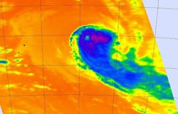
NASA's Aqua satellite passed over Ian on January 13 at 01:23 UTC and saw strongest storms with the coldest cloud tops had temperatures (purple) east and southeast of the center. <br>Image Credit: NASA JPL, AIRS<br>
On January 13 at 0900 UTC/4 a.m. EST, Tropical Cyclone Ian's maximum sustained winds were near 65 knots/74.8 mph/120.4 kph, just at hurricane-strength. Just a day before, Ian's maximum sustained winds were near 80 knots/148.2 kph/92.0 mph.
Ian is moving to the southeast at 14 knots/25.9 kph/16.1 mph and is expected to continue in that direction. Ian was located about 882 nautical miles/1,633 km/1,015 miles south of Pago Pago, near 29.5 south and 169.9 west.
Ian has become significantly elongated as it has been battling strong wind shear. The precipitation has also been sheared to the east.
When NASA's Aqua satellite passed over Ian on January 13 at 01:23 UTC/January 12 at 8:23 p.m. EST, the Atmospheric Infrared Sounder or AIRS instrument captured an infrared picture of the storm. Infrared data showed the temperature of the storm's clouds and the sea surface temperatures surrounding it. The strongest storms with the coldest cloud tops had temperatures as cold as -63F/-52C and the AIRS image showed those storms were clearly pushed east and southeast of the center. The AIRS data also showed warmer, lower cloud top temperatures north and west of Ian's center.
AIRS data showed sea surface temperatures north of Ian were as warm as 300K/26.5C/80.3F/ while those south of Ian (and in the general direction the storm was heading) were near 290K/16.8C/62.3F or cooler.
Over the next couple of days, Ian is expected to become extra-tropical and a cold core low pressure area in the next day and a half.
Ian is no threat to land as it continues on its southeastern track.
Text credit: Rob Gutro
NASA's Goddard Space Flight Center
Media Contact
All latest news from the category: Earth Sciences
Earth Sciences (also referred to as Geosciences), which deals with basic issues surrounding our planet, plays a vital role in the area of energy and raw materials supply.
Earth Sciences comprises subjects such as geology, geography, geological informatics, paleontology, mineralogy, petrography, crystallography, geophysics, geodesy, glaciology, cartography, photogrammetry, meteorology and seismology, early-warning systems, earthquake research and polar research.


Newest articles

Properties of new materials for microchips
… can now be measured well. Reseachers of Delft University of Technology demonstrated measuring performance properties of ultrathin silicon membranes. Making ever smaller and more powerful chips requires new ultrathin…

Floating solar’s potential
… to support sustainable development by addressing climate, water, and energy goals holistically. A new study published this week in Nature Energy raises the potential for floating solar photovoltaics (FPV)…

Skyrmions move at record speeds
… a step towards the computing of the future. An international research team led by scientists from the CNRS1 has discovered that the magnetic nanobubbles2 known as skyrmions can be…

