NASA's Aqua Satellite Sees Typhoon Francisco Approaching Japan
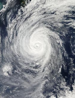
On Oct. 22 at 04:30 UTC/12:30 a.m. EDT, NASA's Aqua satellite captured this stunning visible image of Typhoon Francisco approaching Japan (top left corner in the Pacific Ocean. <br>Image Credit: NASA Goddard MODIS Rapid Response Team<br>
On Oct. 22 at 04:30 UTC/12:30 a.m. EDT, NASA's Aqua satellite captured a stunning visible image of Typhoon Francisco approaching Japan that showed a large storm with a tightly wound center and small eye. Bands of thunderstorms wrapped into the center from the northern and southern quadrants of the storm as Francisco moved toward Japan. The image was created by the NASA MODIS Rapid Response Team at NASA's Goddard Space Flight Center in Greenbelt, Md.
On Oct. 22 at 1500 UTC/11 a.m. EDT, Typhoon Francisco had maximum sustained winds near 75 knots/86.1 mph/138.9 kph. It was centered about 350 nautical miles east-southeast of Kadena Air Base, Okinawa, Japan, near 23.2 north and 133.1 east. The strongest winds, typhoon-force extend 40 nautical miles/46 miles/74 km from the center, or 80 nautical miles/92 miles/148 km in diameter. Tropical-storm-force winds extend as far as 130 nautical miles/149.6 miles/ 240.8 km from the center, making the storm over 260 miles in diameter.
Francisco was moving to the northwest at 7 knots/8 mph/12.9 kph, but is expected to turn to the northeast in the next day or two. As Francisco heads toward Japan, the storm is stirring up very rough seas with wave heights topping 30 feet, according to the Joint Typhoon Warning Center. On Oct. 22, Japan's southern islands were all under advisory status for high waves and/or gale force winds.
Francisco continues to slowly weaken and is expected to become extra-tropical after passing southern Japan in the next couple of days.
Text credit: Rob Gutro
NASA's Goddard Space Flight Center
Media Contact
All latest news from the category: Earth Sciences
Earth Sciences (also referred to as Geosciences), which deals with basic issues surrounding our planet, plays a vital role in the area of energy and raw materials supply.
Earth Sciences comprises subjects such as geology, geography, geological informatics, paleontology, mineralogy, petrography, crystallography, geophysics, geodesy, glaciology, cartography, photogrammetry, meteorology and seismology, early-warning systems, earthquake research and polar research.


Newest articles

Properties of new materials for microchips
… can now be measured well. Reseachers of Delft University of Technology demonstrated measuring performance properties of ultrathin silicon membranes. Making ever smaller and more powerful chips requires new ultrathin…

Floating solar’s potential
… to support sustainable development by addressing climate, water, and energy goals holistically. A new study published this week in Nature Energy raises the potential for floating solar photovoltaics (FPV)…

Skyrmions move at record speeds
… a step towards the computing of the future. An international research team led by scientists from the CNRS1 has discovered that the magnetic nanobubbles2 known as skyrmions can be…

