NASA's Aqua Satellite Sees Small New Tropical Storm Near Tonga
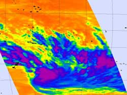
NASA's Aqua satellite captured this image of Tropical Storm 11P, on February 6, 2012 at 0053 UTC. AIRS infrared data from Aqua showed strong thunderstorms with the highest, coldest cloud tops circling the center (purple).<br>Credit: NASA/JPL, Ed Olsen <br>
NASA's Atmospheric Infrared Sounder (AIRS) instrument that flies aboard the Aqua satellite passed over the newest tropical storm in the South Pacific, Tropical Storm 11P, on February 6, 2012 at 0053 UTC (Feb. 5 at 7:53 p.m. EST). AIRS infrared data showed strong thunderstorms with the highest, coldest cloud tops circling the center.
The cloud top temperatures were colder than -63 Fahrenheit (-52.7 Celsius), indicating that some of the thunderstorms were strong. The AIRS data also showed that the storm is small, about 120 nautical miles (138 miles/222 km) in diameter, and there are bands of thunderstorms wrapping into the center of circulation.
On February 6, 2012 at 1500 UTC (10 a.m. EST), Tropical Storm 11P had maximum sustained winds near 35 knots (40.2 mph/64.8 kph). It was about 400 nautical miles (460 miles/~741 km) east of Nadi, Fiji, centered near 18.8 South latitude and 174.5 West longitude. It was moving quickly at 21 knots (~24 mph/~39 kph) to the east-southeast.
Tropical Storm 11P is approaching the main island of Tonga late on February 6. Tonga is a state and an archipelago made up of 176 islands, fifty-two of which are inhabited. It is expected to pass northeast of the main island, Tongatapu.
The Joint Typhoon Warning Center expects Tropical Storm 11P (TS11P) to speed up to the east-southeast to as fast as 30 knots (34.5 mph/55.5 kph). By February 7, TS11P is expected to encounter wind shear and cooler sea surface temperatures, two factors that will weaken it quickly. Forecasters expect that by February 9, the tropical storm will be a remnant low pressure area.
Text Credit: Rob Gutro
NASA's Goddard Space Flight Center, Greenbelt, Md.
Media Contact
All latest news from the category: Earth Sciences
Earth Sciences (also referred to as Geosciences), which deals with basic issues surrounding our planet, plays a vital role in the area of energy and raw materials supply.
Earth Sciences comprises subjects such as geology, geography, geological informatics, paleontology, mineralogy, petrography, crystallography, geophysics, geodesy, glaciology, cartography, photogrammetry, meteorology and seismology, early-warning systems, earthquake research and polar research.


Newest articles

Superradiant atoms could push the boundaries of how precisely time can be measured
Superradiant atoms can help us measure time more precisely than ever. In a new study, researchers from the University of Copenhagen present a new method for measuring the time interval,…

Ion thermoelectric conversion devices for near room temperature
The electrode sheet of the thermoelectric device consists of ionic hydrogel, which is sandwiched between the electrodes to form, and the Prussian blue on the electrode undergoes a redox reaction…

Zap Energy achieves 37-million-degree temperatures in a compact device
New publication reports record electron temperatures for a small-scale, sheared-flow-stabilized Z-pinch fusion device. In the nine decades since humans first produced fusion reactions, only a few fusion technologies have demonstrated…

