Monsoon mission: A better way to predict Indian weather?
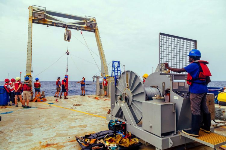
US and Indian scientists aboard the research vessel R/V Roger Revelle deploy a drifting spar buoy to measure upper ocean density and velocity in the Bay of Bengal. The month-long, ONR-sponsored mission centered on monsoon prediction. (Photo courtesy of the R/V Roger Revelle)
Summer, or southwest, monsoons are moisture-soaked seasonal winds that bring critical rainfall to the Indian subcontinent during the June-September wet season. An abundant season provides sustaining rainfall that replenishes water reservoirs and reaps bountiful crop harvests. By contrast, a weak season could lead to drought, soaring food prices and a battered economy.
“This research will lead to an improved understanding and prediction of the ocean and atmosphere,” said Dr. Frank Herr, who heads ONR's Ocean Battlespace Sensing Department. “It also enables ONR to test new and innovative oceanography technology, as well as develop stronger partnerships with Indian scientists.”
Incomplete knowledge of the dynamics of monsoons makes it difficult to accurately predict the onset, strength and intraseasonal variations in the monsoon season. ONR's collaborative research will gather data to help improve and refine the forecasting of these winds.
“The predictability of ocean weather is very important to the Navy's global operations and the safety of ships at seas,” said ONR Program Manager Dr. Terri Paluszkiewicz. “Fundamental studies of monsoon air-sea interaction are crucial for better weather and climate prediction for the entire global community.”
Led by Dr. Amit Tandon, an engineering professor at the University of Massachusetts Dartmouth, approximately 25 American and Indian scientists worked aboard the research vessel R/V Roger Revelle, which is operated by the Scripps Institution of Oceanography under a charter agreement with ONR. Another team of Indian and U.S. scientists on the Indian research vessel Sagar Nidhi worked jointly with those on the Roger Revelle.
Tandon's team studied the uppermost layer of the Bay of Bengal–which is part of the Indian Ocean and a region of monsoon formation. Although the bay is composed of salt water, large amounts of fresh water from rivers and rainstorms dump into it regularly.
“The layer of relatively less salty water near the surface responds rapidly and dramatically to solar heating and nighttime cooling,” said Tandon. “It regulates moisture supply to the atmosphere and can trap the sun's heat beneath the surface of the water, releasing it into the air weeks, or even months, later–increasing the power of a monsoon.”
The researchers used wirewalkers (wave-powered vehicles that can sample water at various depths), buoys, gliders and towed platforms–equipped with data-collecting sensors–to compile information about the Bay of Bengal's water and air temperature, atmospheric moisture, and mixtures and movements of fresh and salt water–all factors contributing to monsoon activity.
“Our field study has mapped out the upper ocean structure of the north Bay of Bengal in unprecedented detail, with cutting-edge oceanography instrumentation, some of which is being used for the first time,” said Tandon.
With this research complete, U.S. and Indian scientists will now analyze the cruise data, in the hopes of eventually designing a computer forecasting model to accurately predict future monsoon formation.
Monsoon research aligns with several tenets of the Cooperative Strategy for 21st Century Seapower, a maritime strategy shared by the U.S. Navy, Marine Corps and Coast Guard. The strategy calls for increased focus on battlespace awareness, which includes surveillance, intelligence gathering and greater knowledge about the environments in which warfighters operate.
Media Contact
All latest news from the category: Earth Sciences
Earth Sciences (also referred to as Geosciences), which deals with basic issues surrounding our planet, plays a vital role in the area of energy and raw materials supply.
Earth Sciences comprises subjects such as geology, geography, geological informatics, paleontology, mineralogy, petrography, crystallography, geophysics, geodesy, glaciology, cartography, photogrammetry, meteorology and seismology, early-warning systems, earthquake research and polar research.


Newest articles

“Nanostitches” enable lighter and tougher composite materials
In research that may lead to next-generation airplanes and spacecraft, MIT engineers used carbon nanotubes to prevent cracking in multilayered composites. To save on fuel and reduce aircraft emissions, engineers…

Trash to treasure
Researchers turn metal waste into catalyst for hydrogen. Scientists have found a way to transform metal waste into a highly efficient catalyst to make hydrogen from water, a discovery that…

Real-time detection of infectious disease viruses
… by searching for molecular fingerprinting. A research team consisting of Professor Kyoung-Duck Park and Taeyoung Moon and Huitae Joo, PhD candidates, from the Department of Physics at Pohang University…

