Major Tropical Cyclone Funso Analyzed by Two NASA Satellites
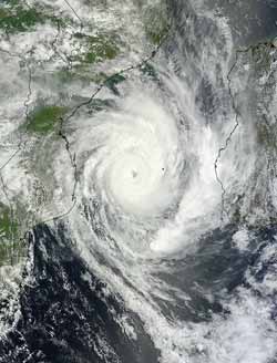
This visible image of Tropical Cyclone Funso was captured by the MODIS instrument on NASA's Aqua satellite on Jan. 25 at 7:40 UTC (2:40 a.m. EST). Tropical Cyclone Funso is still over the Mozambique Channel and its 11 mile-wide eye is clearly visible. Credit: NASA Goddard MODIS Rapid Response Team <br>
Two instruments aboard NASA's Aqua satellite and instruments aboard NASA and JAXA's Tropical Rainfall Measuring Mission (TRMM) satellite provided cloud extent, cloud temperature, rainfall rates, and a look at the eye of the storm.
On Jan. 25 at 7:40 UTC (2:40 a.m. EST), the Moderate Resolution Imaging Spectroradiometer (MODIS) instrument on NASA's Aqua satellite captured a visible image of Tropical Cyclone Funso. The image revealed the cloud cover extends from Mozambique on the African mainland, east to the coast of the island nation of Madagascar. MODIS imagery also revealed a clear 11 mile-wide eye.
When NASA's Aqua satellite passed over Cyclone Funso the day before, January 24 at 11:17 UTC (6:17 a.m. EST) the Atmospheric Infrared Sounder (AIRS) instrument measured the cloud top temperatures. Thunderstorm cloud tops around the entire center of circulation colder than -63 Fahrenheit (-52.7 Celsius) indicating strong storms, dropping heavy rainfall.
The TRMM satellite also had a good view of powerful tropical cyclone Funso battering the Mozambique coast when it flew over on January 24, 2012 at 2204 UTC (5:04 p.m. EST). TRMM data showed that Funso was dropping moderate to heavy rainfall in bands covering the Mozambique Channel from eastern Mozambique to western Madagascar.
On January 25, 2012 at 0900 UTC (4 a.m. EST), Major Tropical Cyclone Funso had maximum sustained winds of 120 knots (138 mph/222 kph). Hurricane-force winds extend out 40 miles (64 km) from the center. It was located near 22.7 South and 38.7 East, about 400 nautical miles (460 miles/741 kmh) northeast of Maputo, Mozambique. It was moving to the south-southwest at 4 knots (~4.6 mph/7.4 kph). Funso is generating maximum significant waves 32 feet (9.7 meters) high.
Cyclone Funso continues to track the over open waters of the southern Mozambique Channel and forecasts take it out into the Southern Indian Ocean over the next three days without any danger of a direct landfall.
Text Credit: Rob Gutro
NASA's Goddard Space Flight Center, Greenbelt, Md.
Media Contact
All latest news from the category: Earth Sciences
Earth Sciences (also referred to as Geosciences), which deals with basic issues surrounding our planet, plays a vital role in the area of energy and raw materials supply.
Earth Sciences comprises subjects such as geology, geography, geological informatics, paleontology, mineralogy, petrography, crystallography, geophysics, geodesy, glaciology, cartography, photogrammetry, meteorology and seismology, early-warning systems, earthquake research and polar research.


Newest articles

“Nanostitches” enable lighter and tougher composite materials
In research that may lead to next-generation airplanes and spacecraft, MIT engineers used carbon nanotubes to prevent cracking in multilayered composites. To save on fuel and reduce aircraft emissions, engineers…

Trash to treasure
Researchers turn metal waste into catalyst for hydrogen. Scientists have found a way to transform metal waste into a highly efficient catalyst to make hydrogen from water, a discovery that…

Real-time detection of infectious disease viruses
… by searching for molecular fingerprinting. A research team consisting of Professor Kyoung-Duck Park and Taeyoung Moon and Huitae Joo, PhD candidates, from the Department of Physics at Pohang University…

