Late season Hurricane Kenneth forms in the eastern Pacific
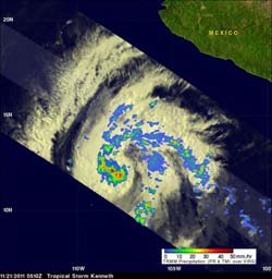
This radar image of Hurricane Kenneth's rainfall was captured by the TRMM satellite on Nov. 21, 2011 at 10:00 a.m. EDT. The red areas indicate heavy rainfall of 2 inches (50 mm) per hour. Light to moderate rainfall (green and blue) was falling at a rate between .78 to 1.57 inches/20 to 40 mm per hour). Credit: Credit: SSAI/NASA, Hal Pierce<br>
Kenneth began as the thirteenth tropical depression and that formed on Saturday, November 19, about 480 miles south of Acapulco, Mexico. On Sunday, November 29 at 0300 UTC (11 p.m. EST, Nov. 19) the National Hurricane Center noted that the center of Tropical Depression 13E was further north than previously estimated and it had intensified into Tropical Storm Kenneth. Kenneth is noteworthy because it is a named storm that is one of the latest forming in the Eastern Pacific Ocean in 28 years.
By 10 a.m. EST on Nov. 21, Kenneth strengthened into a hurricane. Kenneth's maximum sustained winds were near 80 mph (130 kmh) and further strengthening is expected. Kenneth was centered about 705 miles (1135 km) south of the southern tip of Baja California, near 12.7 North and 109.6 west. It was moving to the west-northwest near 14 mph (22 kmh) and had a minimum central pressure of 989 millibars. Kenneth is forecast to turn to the west and slow down.
When the Tropical Rainfall Measuring Mission satellite called “TRMM” passed over Kenneth on Nov. 21 at 15:00 UTC (10:00 a.m. EST) the instruments aboard gathered data that provided a rainfall analysis. The TRMM satellite is co-managed by NASA and JAXA, and the data was created into an image at NASA's Goddard Space Flight Center in Greenbelt, Md. The image showed a ragged eye was forming.
The data from TRMM's Microwave Imager (TMI) and Precipitation Radar (PR) showed heavy rainfall was occurring around Kenneth's center. Some of the heaviest rainfall was falling at a rate of over 2 inches (50 mm) per hour. The TRMM image also revealed a well-defined band of thunderstorms wrapping in the center of circulation as Kenneth continues to strengthen.
Wind shear is expected to be light in Kenneth's path, and although the waters will cool somewhat, Kenneth may still become a major hurricane.
Media Contact
More Information:
http://www.nasa.govAll latest news from the category: Earth Sciences
Earth Sciences (also referred to as Geosciences), which deals with basic issues surrounding our planet, plays a vital role in the area of energy and raw materials supply.
Earth Sciences comprises subjects such as geology, geography, geological informatics, paleontology, mineralogy, petrography, crystallography, geophysics, geodesy, glaciology, cartography, photogrammetry, meteorology and seismology, early-warning systems, earthquake research and polar research.


Newest articles

Silicon Carbide Innovation Alliance to drive industrial-scale semiconductor work
Known for its ability to withstand extreme environments and high voltages, silicon carbide (SiC) is a semiconducting material made up of silicon and carbon atoms arranged into crystals that is…

New SPECT/CT technique shows impressive biomarker identification
…offers increased access for prostate cancer patients. A novel SPECT/CT acquisition method can accurately detect radiopharmaceutical biodistribution in a convenient manner for prostate cancer patients, opening the door for more…

How 3D printers can give robots a soft touch
Soft skin coverings and touch sensors have emerged as a promising feature for robots that are both safer and more intuitive for human interaction, but they are expensive and difficult…

