Landslides linked to plate tectonics create the steepest mountain terrain
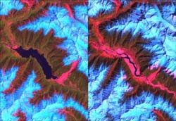
The Landsat satellite image at left shows a huge lake on the Tsangpo River behind a dam created by a landslide (in red, lower right of the lake) in early 2000. The image at right shows the river following a catastrophic breach of the dam in June 2000. Credit: U.S. Geological Survey/NASA<br>
The work, presented online May 27 in Nature Geoscience, shows that once the angle of a slope exceeds 30 degrees – whether from uplift, a rushing stream carving away the bottom of the slope or a combination of the two – landslide erosion increases significantly until the hillside stabilizes.
“I think the formation of these landscapes could apply to any steep mountain terrain in the world,” said lead author Isaac Larsen, a University of Washington doctoral student in Earth and space sciences.
The study, co-authored by David Montgomery, a UW professor of Earth and space sciences and Larsen's doctoral adviser, focuses on landslide erosion along rivers in the eastern Himalaya region of southern Asia.
The scientists studied images of more than 15,000 landslides before 1974 and more than 550 more between 1974 and 2007. The data came from satellite imagery, including high-resolution spy satellite photography that was declassified in the 1990s.
They found that small increases in slope angle above about 30 degrees translated into large increases in landslide erosion as the stress of gravity exceeded the strength of the bedrock.
“Interestingly, 35 degrees is about the same angle that will form if sand or other coarse granular material is poured into a pile,” Larsen said. “Sand is non-cohesive, whereas intact bedrock can have high cohesion and should support steeper slopes.
“The implication is that bedrock in tectonically active mountains is so extensively fractured that in some ways it behaves like a sand pile. Removal of sand at the base of the pile will cause miniature landslides, just as erosion of material at the base of hill slopes in real mountain ranges will lead to landslides.”
The researchers looked closely at an area of the 150-mile Tsangpo Gorge in southeast Tibet, possibly the deepest gorge in the world, downstream from the Yarlung Tsangpo River where the Po Tsangpo River plunges more than 6,500 feet, about 1.25 miles. It then becomes the Brahmaputra River before flowing through the Ganges River delta and into the Bay of Bengal.
The scientists found that within the steep gorge, the rapidly flowing water can scour soil from the bases, or toes, of slopes, leaving exposed bedrock and an increased slope angle that triggers landslides to stabilize the slopes.
From 1974 through 2007, erosion rates reached more than a half-inch per year along some 6-mile stretches of the river within the gorge, and throughout that active landslide region erosion ranged from 0.15 to 0.8 inch per year. Areas with less tectonic and landslide activity experienced erosion rates of less than 0.15 inch a year.
Images showed that a huge landslide in early 2000 created a gigantic dam on a stretch of the Po Tsangpo. The dam failed catastrophically in June of that year, and the ensuing flood caused a number of fatalities and much property damage downstream.
That event illustrates the processes at work in steep mountain terrain, but the processes happen on a faster timescale in the Tsangpo Gorge than in other steep mountain regions of the world and so are more easily verified.
“We've been able to document the role that landslides play in the Tsangpo Gorge,” Larsen said. “It explains how steep mountain topography evolves over time.”
The work was financed by NASA, the Geological Society of America, Sigma Xi (the Scientific Research Society) and the UW Quaternary Research Center and Department of Earth and Space Sciences.
For more information, contact Larsen at 206-265-0473 or larseni@uw.edu, or Montgomery at 206-685-2560 or dave@ess.washington.edu
Media Contact
More Information:
http://www.uw.eduAll latest news from the category: Earth Sciences
Earth Sciences (also referred to as Geosciences), which deals with basic issues surrounding our planet, plays a vital role in the area of energy and raw materials supply.
Earth Sciences comprises subjects such as geology, geography, geological informatics, paleontology, mineralogy, petrography, crystallography, geophysics, geodesy, glaciology, cartography, photogrammetry, meteorology and seismology, early-warning systems, earthquake research and polar research.


Newest articles

Combatting disruptive ‘noise’ in quantum communication
In a significant milestone for quantum communication technology, an experiment has demonstrated how networks can be leveraged to combat disruptive ‘noise’ in quantum communications. The international effort led by researchers…

Stretchable quantum dot display
Intrinsically stretchable quantum dot-based light-emitting diodes achieved record-breaking performance. A team of South Korean scientists led by Professor KIM Dae-Hyeong of the Center for Nanoparticle Research within the Institute for…

Internet can achieve quantum speed with light saved as sound
Researchers at the University of Copenhagen’s Niels Bohr Institute have developed a new way to create quantum memory: A small drum can store data sent with light in its sonic…

