Infrared NASA Imagery Shows Sinking Air, Elongation in Tropical Storm Emang
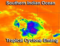
NASA infrared data on Tropical Storm Emang captured by NASA's Aqua satellite on Jan. 15 at 0823 UTC (3:23 a.m. EST) showed that the largest area of powerful thunderstorms (purple) were in the northern half of the storm. That are is where heaviest rain was falling. Credit: NASA JPL, Ed Olsen<br>
Infrared data on Tropical Storm Emang's cloud top temperatures was captured by the Atmospheric Infrared Sounder (AIRS) instrument on Jan. 15 at 0823 UTC (3:23 a.m. EST). AIRS data showed that the largest area of powerful thunderstorms were in the northern half of the storm. That area showed cold cloud top temperatures of -63F (-52C) indicating high, powerful thunderstorms where the heaviest rain was falling.
The AIRS data also showed that sinking air or subsidence was occurring in the southwestern quadrant of the storm, which is weakening the convection there.
AIRS data also showed that the low level center of circulation had become slightly elongated, stretching from southwest to northeast. For a tropical cyclone to intensify, its circulation centers from the surface to upper atmosphere basically have to stack up. When the center becomes elongated the storm usually has a difficult time intensifying.
On Jan. 15 at 0900 UTC, Tropical Storm Emang's maximum sustained winds were near 35 knots (40.2 mph/64.8 kph). Emang is moving slowly to the south-southwest at 4 knots (4.6 mph/7.4 kph). Emang was centered near 13.5 south latitude and 78.6 east longitude, about 525 nautical miles (604.2 miles/ 972.3 km) southeast of Diego Garcia. Diego Garcia is a coral atoll in the central southern Indian Ocean.
Forecasters at the Joint Typhoon Warning Center expect atmospheric conditions to improve over the coming days, so that Emang can organize and strengthen. Fortunately, the storm is no threat to land.
Text Credit: Rob Gutro
NASA's Goddard Space Flight Center, Greenbelt, Md.
Media Contact
All latest news from the category: Earth Sciences
Earth Sciences (also referred to as Geosciences), which deals with basic issues surrounding our planet, plays a vital role in the area of energy and raw materials supply.
Earth Sciences comprises subjects such as geology, geography, geological informatics, paleontology, mineralogy, petrography, crystallography, geophysics, geodesy, glaciology, cartography, photogrammetry, meteorology and seismology, early-warning systems, earthquake research and polar research.


Newest articles

Properties of new materials for microchips
… can now be measured well. Reseachers of Delft University of Technology demonstrated measuring performance properties of ultrathin silicon membranes. Making ever smaller and more powerful chips requires new ultrathin…

Floating solar’s potential
… to support sustainable development by addressing climate, water, and energy goals holistically. A new study published this week in Nature Energy raises the potential for floating solar photovoltaics (FPV)…

Skyrmions move at record speeds
… a step towards the computing of the future. An international research team led by scientists from the CNRS1 has discovered that the magnetic nanobubbles2 known as skyrmions can be…

