Infrared NASA Imagery Shows a Weaker Tropical Storm 13W
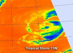
NASA's Aqua satellite passed over Tropical Storm 13W on August 7 at 0253 UTC. The AIRS instrument captured an infrared image of the cloud temperatures that showed very limited strong storms (purple) and most of the precipitation was to the east of the center of circulation.<br>Credit: NASA JPL, Ed Olsen <br>
Infrared satellite imagery from shows how cold cloud top temperatures are in a tropical cyclone, and recent imagery from NASA's Aqua satellite shows the cloud-top temperatures have been warming in Tropical Storm 13W. Warming cloud top temperatures indicate less strength, and Tropical Storm 13W is weakening.
NASA's Aqua satellite passed over Tropical Storm 13W on August 7 at 0253 UTC. The Atmospheric Infrared Sounder (AIRS) instrument that flies onboard Aqua captured an infrared image of the storm's cloud temperatures that showed very limited strong thunderstorms make up the tropical cyclone and most of the precipitation was to the east of the center of circulation. The AIRS imagery also shows that the bands of thunderstorms around the center are fragmented.
On August 7 at 1500 UTC (11 a.m. EDT), Tropical Storm 13W's (TS13W) maximum sustained winds were near 35 knots (40.2 mph/64.8 kmh). TS13W was located 745 nautical miles (857 miles/1,380 km) north-northwest of Wake Island, near 30.2 North and 160.5 East. It was moving to the northwest near 9 knots (10.3 mph/16.6 kmh).
The Joint Typhoon Warning Center forecasters noted that Tropical Storm 13W “Continues to maintain a warm core and will likely dissipate before transitioning to a subtropical or extra-tropical system.”
Text Credit: Rob Gutro
NASA Goddard Space Flight Center, Greenbelt, Md.
Media Contact
All latest news from the category: Earth Sciences
Earth Sciences (also referred to as Geosciences), which deals with basic issues surrounding our planet, plays a vital role in the area of energy and raw materials supply.
Earth Sciences comprises subjects such as geology, geography, geological informatics, paleontology, mineralogy, petrography, crystallography, geophysics, geodesy, glaciology, cartography, photogrammetry, meteorology and seismology, early-warning systems, earthquake research and polar research.


Newest articles
Making diamonds at ambient pressure
Scientists develop novel liquid metal alloy system to synthesize diamond under moderate conditions. Did you know that 99% of synthetic diamonds are currently produced using high-pressure and high-temperature (HPHT) methods?[2]…

Eruption of mega-magnetic star lights up nearby galaxy
Thanks to ESA satellites, an international team including UNIGE researchers has detected a giant eruption coming from a magnetar, an extremely magnetic neutron star. While ESA’s satellite INTEGRAL was observing…

Solving the riddle of the sphingolipids in coronary artery disease
Weill Cornell Medicine investigators have uncovered a way to unleash in blood vessels the protective effects of a type of fat-related molecule known as a sphingolipid, suggesting a promising new…

