Infrared NASA imagery reveals a weaker tropical cyclone in the South China Sea
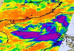
NASA's AIRS instrument on the Aqua satellite captured this infrared image of 06W on June 20 at 18:05 UTC (2:05 p.m. EDT) when it was still a tropical storm. The purple areas represent icy cold temperatures of -63F/-52C and high, strong thunderstorms. The storm has weakened and appears much more disorganized today. Credit: NASA/JPL, Ed Olsen<br>
On June 21 at 1500 UTC (11 a.m. EDT) the newly weakened Tropical Depression 06W was located about 480 nautical miles east-southeast of Hanoi, Vietnam near 18.8 North and 113.8 East. Depression 06W's maximum sustained winds had decreased to 25 knots (28 mph/46 kmh). It was moving west-southwest at 9 knots (10 mph/17 kmh) and kicking up 11 foot-high waves in the South China Sea.
NASA's Atmospheric Infrared Sounder (AIRS) instrument that flies on the Aqua satellite captured an infrared image of 06W on June 20 at 18:05 UTC (2:05 p.m. EDT) when it was still a tropical storm. Since then, convection has become more scattered and winds have lessened. In addition, the low level center of the storm's circulation has become elongated due to wind shear. Elongation of a tropical cyclone is a sign of weakening.
Because of that wind shear, 06W is expected to barely maintain tropical depression strength before it makes landfall on Thursday, June 23 near Jhan Jiang, China.
The AIRS infrared image captures cloud top temperatures and the coldest temperatures appeared south of the center of circulation. Those cold cloud top temperatures represented the strongest thunderstorms in the tropical storm where rainfall rates could reach up to 2 inches / 50 mm per hour.
Because Tropical Depression 06W has begun moving to the west-southwest, the Joint Typhoon Warning Center has changed the forecast track and taken the depression farther south. The current landfall takes 06W just north of Hainan Island, China and then onto the mainland at the southwestern end of Guangdong province of Southern China.
NASA's Hurricane page: www.nasa.gov/hurricane
Media Contact
All latest news from the category: Earth Sciences
Earth Sciences (also referred to as Geosciences), which deals with basic issues surrounding our planet, plays a vital role in the area of energy and raw materials supply.
Earth Sciences comprises subjects such as geology, geography, geological informatics, paleontology, mineralogy, petrography, crystallography, geophysics, geodesy, glaciology, cartography, photogrammetry, meteorology and seismology, early-warning systems, earthquake research and polar research.


Newest articles

Superradiant atoms could push the boundaries of how precisely time can be measured
Superradiant atoms can help us measure time more precisely than ever. In a new study, researchers from the University of Copenhagen present a new method for measuring the time interval,…

Ion thermoelectric conversion devices for near room temperature
The electrode sheet of the thermoelectric device consists of ionic hydrogel, which is sandwiched between the electrodes to form, and the Prussian blue on the electrode undergoes a redox reaction…

Zap Energy achieves 37-million-degree temperatures in a compact device
New publication reports record electron temperatures for a small-scale, sheared-flow-stabilized Z-pinch fusion device. In the nine decades since humans first produced fusion reactions, only a few fusion technologies have demonstrated…

