Guchol is a tiny typhoon on NASA satellite imagery
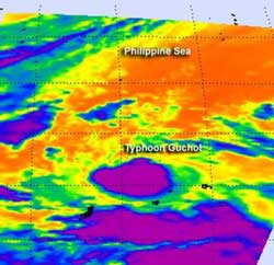
NASA's Aqua satellite flew over Typhoon Guchol on June 13 at 1635 UTC (12:35 p.m. EDT) and captured an infrared view of the storm's clouds and temperatures. The AIRS instrument on Aqua captured infrared and temperature data on Guchol. The lowest temperatures were as cold as or colder than 220 degrees Kelvin or minus 63 degrees Fahrenheit (-52 Celsius) and appear in purple.<br>Credit: Credit: NASA/JPL, Ed Olsen<br>
NASA's Aqua satellite flew over Typhoon Guchol on June 13 and 14 and captured an infrared view of the storm's clouds and temperatures. The Atmospheric Infrared Sounder (AIRS) instrument that flies on NASA's Aqua satellite captured infrared and temperature data on Guchol. When cloud temperatures get colder, it means that clouds are getting higher.
The lowest temperatures were as cold as or colder than 220 degrees Kelvin or minus 63 degrees Fahrenheit (-52 Celsius). The imagery also showed a small, compact system with a central dense overcast, about 120 miles (~193 km) in diameter. Satellite imagery also showed tightly-curved bands of thunderstorms wrapping into a well-defined low-level circulation center.
As Guchol is expected to impact the east central and northeastern Luzon over the next couple of days, forecasters in the Philippines are calling Guchol “Butchoy.”
At 1500 UTC (11 a.m. EDT/U.S. or 11 p.m. Asia/Manila time, Philippines), Guchol had maximum sustained winds near 70 knots (~80 mph/~130 kph). Tropical storm-force winds extend out about 60 miles (96.5 km) from the center (making the storm about 120 miles (193.1 km) in diameter), while typhoon-force winds extend only 20 nautical miles (23 miles/37 km) from the center.
It was located about 750 nautical miles (863.1 miles/1389 km) east-southeast of Manila, Philippines near 10.8 North and 132.7 East, so it was quite a distance from land. It was moving to the west near 12 knots (~14 mph/~22 kph). Typhoon Guchol is still on track to brush east central and northern Luzon, Philippines beginning June 15 as it moves north-northeast and toward southern Japan. Interests in the Philippines and Okinawa, Japan should monitor the progress of this storm.
Media Contact
More Information:
http://www.nasa.govAll latest news from the category: Earth Sciences
Earth Sciences (also referred to as Geosciences), which deals with basic issues surrounding our planet, plays a vital role in the area of energy and raw materials supply.
Earth Sciences comprises subjects such as geology, geography, geological informatics, paleontology, mineralogy, petrography, crystallography, geophysics, geodesy, glaciology, cartography, photogrammetry, meteorology and seismology, early-warning systems, earthquake research and polar research.


Newest articles

Properties of new materials for microchips
… can now be measured well. Reseachers of Delft University of Technology demonstrated measuring performance properties of ultrathin silicon membranes. Making ever smaller and more powerful chips requires new ultrathin…

Floating solar’s potential
… to support sustainable development by addressing climate, water, and energy goals holistically. A new study published this week in Nature Energy raises the potential for floating solar photovoltaics (FPV)…

Skyrmions move at record speeds
… a step towards the computing of the future. An international research team led by scientists from the CNRS1 has discovered that the magnetic nanobubbles2 known as skyrmions can be…

