GPM sees deadly tornadic storms moving through US Southeast
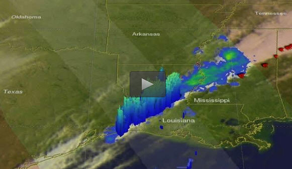
The GPM core observatory satellite viewed a western portion of a line of violent weather when it flew over on Tuesday, Nov. 29 at 11:16 p.m. EST. The areas covered by GPM's Microwave Imager (GMI) and Dual-Frequency Precipitation Radar (DPR) instruments are shown in lighter shades. Red symbols show the approximate locations where tornadoes were reported. Credits: NASA/JAXA, Hal Pierce
Tornadoes caused the deaths of at least five people in northern Alabama. Storms also took the lives of two people in Tennessee.
This rainfall may provide some relief to drought ridden eastern Tennessee where destructive wildfires have been occurring. Some storms were accompanied with hail, strong winds and intense showers. Golf ball sized hail was reported in a storm that passed through Louisiana Tuesday evening.
The GPM core observatory satellite viewed a western portion of a line of violent weather when it flew over on Tuesday, Nov. 29 at 11:16 p.m. EST (November 30, 2016 0416 UTC). GPM found that rain was falling at a rate of over 5.7 inches (144.8 mm) per hour in a heavy downpours over southwestern Louisiana.
At NASA's Goddard Space Flight Center in Greenbelt, Maryland, GPM's Dual-Frequency Precipitation Radar (DPR) data was used to produce a 3-D view of the precipitation within storms that were moving over Louisiana. Storm tops were measured by GPM's radar (Ka and Ku band) reaching heights above 8 miles (13 km).
On Nov. 30, NOAA's National Weather Service Storm Prediction Center (SPC) noted “Storms will be capable of producing damaging winds, hail, heavy downpours, and a few tornadoes.
Heavy rainfall could lead to localized flooding of low lying and poor drainage areas. Additional heavy rainfall will also be possible from the Appalachians to the Middle Atlantic Region.” For updated information from the SPC, visit: http://www.
Media Contact
All latest news from the category: Earth Sciences
Earth Sciences (also referred to as Geosciences), which deals with basic issues surrounding our planet, plays a vital role in the area of energy and raw materials supply.
Earth Sciences comprises subjects such as geology, geography, geological informatics, paleontology, mineralogy, petrography, crystallography, geophysics, geodesy, glaciology, cartography, photogrammetry, meteorology and seismology, early-warning systems, earthquake research and polar research.


Newest articles

Combatting disruptive ‘noise’ in quantum communication
In a significant milestone for quantum communication technology, an experiment has demonstrated how networks can be leveraged to combat disruptive ‘noise’ in quantum communications. The international effort led by researchers…

Stretchable quantum dot display
Intrinsically stretchable quantum dot-based light-emitting diodes achieved record-breaking performance. A team of South Korean scientists led by Professor KIM Dae-Hyeong of the Center for Nanoparticle Research within the Institute for…

Internet can achieve quantum speed with light saved as sound
Researchers at the University of Copenhagen’s Niels Bohr Institute have developed a new way to create quantum memory: A small drum can store data sent with light in its sonic…

