Fukushima at increased earthquake risk
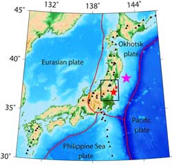
(From the paper.) Map of Japan’s islands indicating the area of study (black box). The purple star marks the epicentre of the 11 March earthquake and the red star the Iwaki epicentre. Fukushima Daiichi is highlighted by a red square. Black triangles indicate active volcanoes. Numbers on the side of the image represent latitude and longitude. Credit: Ping Tong, Dapeng Zhao and Dinghui Yang<br>
The new study, which uses data from over 6,000 earthquakes, shows the 11 March tremor caused a seismic fault close to the nuclear plant to reactivate. The results are now published in Solid Earth, an open-access journal of the European Geosciences Union (EGU).
The research suggests authorities should strengthen the security of the Fukushima Daiichi nuclear power plant to withstand large earthquakes that are likely to directly disturb the region. The power plant witnessed one of the worst nuclear disasters in history after it was damaged by the 11 March 2011 magnitude 9 earthquake and tsunami. But this tremor occurred about 160 km from the site, and a much closer one could occur in the future at Fukushima.
¡°There are a few active faults in the nuclear power plant area, and our results show the existence of similar structural anomalies under both the Iwaki and the Fukushima Daiichi areas. Given that a large earthquake occurred in Iwaki not long ago, we think it is possible for a similarly strong earthquake to happen in Fukushima,¡± says team-leader Dapeng Zhao, geophysics professor at Japan¡¯s Tohoku University.
The 11 April 2011 magnitude 7 Iwaki earthquake was the strongest aftershock of the 11 March earthquake with an inland epicentre. It occurred 60 km southwest of the Fukushima nuclear power plant, or 200 km from the 11 March epicentre.
The research now published in EGU¡¯s Solid Earth shows that the Iwaki earthquake was triggered by fluids moving upwards from the subducting Pacific plate to the crust. The Pacific plate is moving beneath northeast Japan, which increases the temperature and pressure of the minerals in it. This leads to the removal of water from minerals, generating fluids that are less dense than the surrounding rock. These fluids move up to the upper crust and may alter seismic faults.
¡°Ascending fluids can reduce the friction of part of an active fault and so trigger it to cause a large earthquake. This, together with the stress variations caused by the 11 March event, is what set off the Iwaki tremor,¡± says Ping Tong, lead author of the paper.
The number of earthquakes in Iwaki increased greatly after the March earthquake. The movements in the Earth¡¯s crust induced by the event caused variations in the seismic pressure or stress of nearby faults. Around Iwaki, Japan¡¯s seismic network recorded over 24,000 tremors from 11 March 2011 to 27 October 2011, up from under 1,300 detected quakes in the nine years before, the scientists report.
The 6,000 of these earthquakes selected for the study were recorded by 132 seismographic stations in Japan from June 2002 to October 2011. The researchers analysed these data to take pictures of the Earth¡¯s interior, using a technique called seismic tomography.
¡°The method is a powerful tool to map out structural anomalies, such as ascending fluids, in the Earth¡¯s crust and upper mantle using seismic waves. It can be compared to a CT or CAT scan, which relies on X-rays to detect tumours or fractures inside the human body,¡± explains Zhao.
While the scientists can¡¯t predict when an earthquake in Fukushima Daiichi will occur, they state that the ascending fluids observed in the area indicate that such an event is likely to occur in the near future. They warn that more attention should be paid to the site¡¯s ability to withstand strong earthquakes, and reduce the risk of another nuclear disaster.
The scientists also note that the results may be useful for reviewing seismic safety in other nuclear facilities in Japan, such as nearby Fukushima Daini, Onagawa to the north of Fukushima, and T¨kai to the south.
Information for editors
This research is presented in the paper ¡®Tomography of the 2011 Iwaki earthquake (M 7.0) and Fukushima nuclear power plant area¡¯ to appear in the EGU open-access journal Solid Earth on 14 February 2012.
The scientific article is available online, from the publication date onwards, at http://www.solid-earth.net/recent_papers.html.
The discussion paper (not peer-reviewed) and reviewers comments is available at http://www.solid-earth-discuss.net/3/1021/2011/sed-3-1021-2011.html.
The team is composed of Ping Tong (Tohoku University, Sendai, Japan [Tohoku] and Tsinghua University, Beijing, China [Tsinghua]), Dapeng Zhao (Tohoku), Dinghui Yang (Tsinghua).
The European Geosciences Union (EGU, www.egu.eu) is Europe¡¯s premier geosciences union, dedicated to the pursuit of excellence in the Earth, planetary, and space sciences for the benefit of humanity, worldwide. It is a non-profit interdisciplinary learned association of scientists founded in 2002. The EGU has a current portfolio of 14 diverse scientific journals, which use an innovative open-access format, and organises a number of topical meetings, and education and outreach activities. Its annual General Assembly is the largest and most prominent European geosciences event, attracting over 10,000 scientists from all over the world. The meeting¡¯s sessions cover a wide range of topics, including volcanology, planetary exploration, the Earth¡¯s internal structure and atmosphere, climate change, and renewable energies.
The 2012 EGU General Assembly is taking place is Vienna, Austria from 22-27 April. For information regarding the press centre at the meeting and media registration, please check http://media.egu2012.eu/.
Contacts
Prof Dapeng Zhao
Department of Geophysics, Tohoku University
Sendai, Japan
Tel: +81-22-225-1950 or +81-22-795-6780
Email: zhao@aob.gp.tohoku.ac.jp
B¨¢rbara T. Ferreira
EGU Media and Communications Officer
Munich, Germany
Tel: +49-89-2180-6703
Email: media@egu.eu
Media Contact
All latest news from the category: Earth Sciences
Earth Sciences (also referred to as Geosciences), which deals with basic issues surrounding our planet, plays a vital role in the area of energy and raw materials supply.
Earth Sciences comprises subjects such as geology, geography, geological informatics, paleontology, mineralogy, petrography, crystallography, geophysics, geodesy, glaciology, cartography, photogrammetry, meteorology and seismology, early-warning systems, earthquake research and polar research.


Newest articles

Silicon Carbide Innovation Alliance to drive industrial-scale semiconductor work
Known for its ability to withstand extreme environments and high voltages, silicon carbide (SiC) is a semiconducting material made up of silicon and carbon atoms arranged into crystals that is…

New SPECT/CT technique shows impressive biomarker identification
…offers increased access for prostate cancer patients. A novel SPECT/CT acquisition method can accurately detect radiopharmaceutical biodistribution in a convenient manner for prostate cancer patients, opening the door for more…

How 3D printers can give robots a soft touch
Soft skin coverings and touch sensors have emerged as a promising feature for robots that are both safer and more intuitive for human interaction, but they are expensive and difficult…

