Finger on the pulse of wetlands
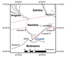
The triangular Linyanti Wetlands lie in Namibia on the border with Botswana. The national borders are marked in red. Image: Tobias Landmann<br>
Wetlands like the Okavango Delta in southern Africa play an important role ecologically and economically. Not only do they provide a habitat for numerous species of animals and plants, they also have benefits for people. Often they are the only major water reservoir in an otherwise dry landscape. They also attract tourists and as such contribute to the livelihoods of local inhabitants.
Recording changes in wetlands
What impact will climate change have on such wetlands in Africa? It is predicted that this continent will become hotter and drier as a result of global changes. This might make the wetlands even more important in their role as water stores. But it might also completely dry them out.
“We need to be able to take the ‘pulse’ of the wetlands continuously so that we can observe changes and introduce any necessary countermeasures,” says Dr. Tobias Landmann from the University of Würzburg. This geographer, with his colleagues Christian Hüttich, Matthias Schramm, and Stefan Dech, has now made it possible to do this for the very first time. The journal “Remote Sensing Letters” presents the scientists’ method in its latest issue.
Finger on the pulse of the Linyanti Wetlands
The researchers chose the Linyanti Wetlands as their study object. This area is roughly 40 by 60 kilometers in size and lies in the east of Namibia on the border with Botswana, right in the middle of the dry savannah. It is fed by the Kwando River, which flows into a large delta in the Linyanti region, creating a considerable landscape of rivers and lakes.
How can we take the “pulse” of the Linyanti region continuously? Landmann and his colleagues have succeeded in doing this using image data from the NASA satellite MODIS. The satellite supplied high-resolution images of these African wetlands on an almost daily basis between 2001 and 2010. They clearly show the degree of flooding and the vitality of the vegetation, which are precisely the factors that interested the researchers since they wanted to know the following: how moist and green was Linyanti during this period, how did this fluctuate over the course of a year, and how did this vary from one year to another?
The Würzburg scientists took the satellite data and applied the so-called vector method to calculate the intensity and direction of the changes. This revealed that in some years the Linyanti region was drier, while in others it was more moist again. But, on the whole, the region became considerably more moist from 2001 to 2010.
“However, this does not allow any reliable statement regarding climate change because the time frame of just ten years is much too short,” says Landmann. This would require considerably longer time series. Such long-term measurements can now be undertaken for the earth’s wetlands for the first time – thanks to the wealth of satellite data available and thanks to the new method from Würzburg.
“MODIS based change vector analysis for assessing wetland dynamics in Southern Africa”, T. Landmann, M. Schramm, C. Huettich, and S. Dech, Remote Sensing Letters, published online 20 June 2012, DOI: 10.1080/2150704X.2012.699201
Contact
Dr. Tobias Landmann, Department of Remote Sensing, Institute of Geography and Geology at the University of Würzburg, T +49 (0)931 31-81869, tobias.landmann@uni-wuerzburg.de
Media Contact
More Information:
http://www.uni-wuerzburg.deAll latest news from the category: Earth Sciences
Earth Sciences (also referred to as Geosciences), which deals with basic issues surrounding our planet, plays a vital role in the area of energy and raw materials supply.
Earth Sciences comprises subjects such as geology, geography, geological informatics, paleontology, mineralogy, petrography, crystallography, geophysics, geodesy, glaciology, cartography, photogrammetry, meteorology and seismology, early-warning systems, earthquake research and polar research.


Newest articles

Properties of new materials for microchips
… can now be measured well. Reseachers of Delft University of Technology demonstrated measuring performance properties of ultrathin silicon membranes. Making ever smaller and more powerful chips requires new ultrathin…

Floating solar’s potential
… to support sustainable development by addressing climate, water, and energy goals holistically. A new study published this week in Nature Energy raises the potential for floating solar photovoltaics (FPV)…

Skyrmions move at record speeds
… a step towards the computing of the future. An international research team led by scientists from the CNRS1 has discovered that the magnetic nanobubbles2 known as skyrmions can be…

