Fernand's Remnants Still Drenching Eastern Mexico
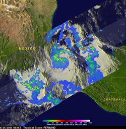
On Monday August 26 at 1:34 a.m. EDT, NASA's TRMM satellite saw Tropical Storm Fernand already drenching the state of Veracruz along Mexico's eastern coast, while System 95E was soaking the west coast. Image Credit: SSAI/NASA, Hal Pierce<br>
On Aug. 27 at 10:32 EDT, radar data from Mexico showed rainfall streaming in from near the city of Tampico on the Gulf of Mexico, to the west and northwest. Areas including Ebano and Panuco were experiencing heavy rainfall at the time.
The center of Fernand's remnants were near 20.6 north latitude and 98.5 west longitude, which is between the states of Hidalgo and Veracruz. Fernand's remnants are keeping the region cloud-covered, as seen on NOAA's GOES-East satellite imagery. The GOES imagery, created by NASA's GOES Project at NASA Goddard Space Flight Center
The National Meteorological Service or NMS of Mexico expects Fernand's remnants to generate intense and heavy rain to the northeastern states, east and central Mexico. A warning remains in effect for heavy rainfall. The NMS of Mexico noted that heavy rainfall is possible on Aug. 27 in Veracruz, Puebla, Hidalgo, San Luis Potosi and Tamaulipas. Heavy rainfall is also possible in Distrito Federal, Tlaxcala and Queretaro.
On Monday August 26 at 0534 UTC (1:34 a.m. EDT), Tropical Storm Fernand was already drenching the state of Veracruz along Mexico's eastern coast on the Gulf of Mexico when NASA's TRMM satellite flew overhead. TRMM, the Tropical Rainfall Measuring Mission Satellite captured data about the rainfall rates occurring in Fernand at the time.
That data was visualized at NASA's Goddard Space Flight Center in Greenbelt, Md. A rainfall analysis from TRMM's Microwave Imager (TMI) and Precipitation Radar (PR) instruments was overlaid on an enhanced infrared image from TRMM's Visible and InfraRed Scanner (VIRS). The TRMM PR found rain falling at a rate of over 118mm/~4.6 inches per hour in rain bands north of Fernand's center of circulation. Those same TRMM PR data clearly showed the location of Fernand's nearly rain free center of circulation.
TRMM's Precipitation Radar (PR) data were used at NASA to create a 3-D image of the storm's structure. TRMM also captured imagery of nearby System 95E in the eastern Pacific. In that storm, the tallest thunderstorm tops were found to reach heights of above 18.5 km/~10.9 miles. Those powerful storms were located off Mexico's Pacific coast southeast of Acapulco.
Heavy rainfall from Fernand may still produce some life threatening flash floods and mudslides today.
Text credit: Hal Pierce/Rob Gutro
SSAI/NASA's Goddard Space Flight Center
Media Contact
All latest news from the category: Earth Sciences
Earth Sciences (also referred to as Geosciences), which deals with basic issues surrounding our planet, plays a vital role in the area of energy and raw materials supply.
Earth Sciences comprises subjects such as geology, geography, geological informatics, paleontology, mineralogy, petrography, crystallography, geophysics, geodesy, glaciology, cartography, photogrammetry, meteorology and seismology, early-warning systems, earthquake research and polar research.


Newest articles

Machine learning algorithm reveals long-theorized glass phase in crystal
Scientists have found evidence of an elusive, glassy phase of matter that emerges when a crystal’s perfect internal pattern is disrupted. X-ray technology and machine learning converge to shed light…

Mapping plant functional diversity from space
HKU ecologists revolutionize ecosystem monitoring with novel field-satellite integration. An international team of researchers, led by Professor Jin WU from the School of Biological Sciences at The University of Hong…

Inverters with constant full load capability
…enable an increase in the performance of electric drives. Overheating components significantly limit the performance of drivetrains in electric vehicles. Inverters in particular are subject to a high thermal load,…

