An eye-opener: NASA sees Hurricane Raymond reborn for a brief time
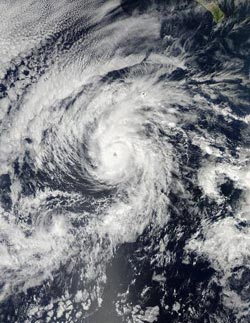
The MODIS instrument aboard NASA's Aqua satellite captured this visible image of Hurricane Raymond, re-strengthened in the Eastern Pacific. The image was taken on Oct. 27 at 21:15 UTC/5:15 p.m. EDT.<br><br>Credit: NASA Goddard MODIS Rapid Response Team<br>
The Moderate Resolution Imaging Spectroradiometer or MODIS instrument aboard NASA's Aqua satellite captured a visible image of Hurricane Raymond that showed its eye had re-developed and opened after it re-strengthened in the Eastern Pacific. The image was taken on Oct. 27 at 21:15 UTC/5:15 p.m. EDT.
By Oct. 28, wind shear had again kicked up again and Raymond was weakening. Wind shear increased from the southwest pushing the strongest convection, and showers and thunderstorms northeast of the center.
An infrared, false-colored image of Hurricane Raymond was taken by the Atmospheric Infrared Sounder or AIRS instrument aboard NASA's Aqua satellite on Oct. 28 at 9:23 UTC/5:23 a.m. EDT. The AIRS infrared image showed that the strongest storms had been displaced to the northeast of the center as a result of southwesterly wind shear. Those strong storms were still showing cold cloud top temperatures in excess of -63F/-52C indicating they were high in the troposphere and had the potential to generate heavy rain.
At 11 a.m. EDT/1500 UTC, Hurricane Raymond's maximum sustained winds were near 85 mph/140 kph and weakening. The center of Hurricane Raymond was near latitude 16.4 north and longitude 117.0 west, about 645 miles/1,035 km southwest of the southern tip of Mexico's Baja California. Raymond was moving toward the north near 7 mph/11 kph and is expected to turn toward the north-northeast. Raymond is forecast to weaken to a tropical storm late on Oct. 28 and a depression later that day.
The National Hurricane Center noted on Oct. 28 that Raymond is moving into an area with stronger wind shear, cooler sea surface temperatures and drier air: three factors that will lead to its dissipation in the next couple of days.
Media Contact
More Information:
http://www.nasa.govAll latest news from the category: Earth Sciences
Earth Sciences (also referred to as Geosciences), which deals with basic issues surrounding our planet, plays a vital role in the area of energy and raw materials supply.
Earth Sciences comprises subjects such as geology, geography, geological informatics, paleontology, mineralogy, petrography, crystallography, geophysics, geodesy, glaciology, cartography, photogrammetry, meteorology and seismology, early-warning systems, earthquake research and polar research.


Newest articles

Properties of new materials for microchips
… can now be measured well. Reseachers of Delft University of Technology demonstrated measuring performance properties of ultrathin silicon membranes. Making ever smaller and more powerful chips requires new ultrathin…

Floating solar’s potential
… to support sustainable development by addressing climate, water, and energy goals holistically. A new study published this week in Nature Energy raises the potential for floating solar photovoltaics (FPV)…

Skyrmions move at record speeds
… a step towards the computing of the future. An international research team led by scientists from the CNRS1 has discovered that the magnetic nanobubbles2 known as skyrmions can be…

