Now Extra-Tropical Daphne, left flooding behind in Fuji on NASA satellite imagery
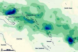
NASA's TRMM satellite showed heavy rainfall totals between Papua New Guinea and Fiji from March 26 to April 2, 2012 as a result of System 95P, which later became Tropical Storm Daphne. The heaviest rainfall -- more than 600 millimeters, or 24 inches -- appears in dark blue. The lightest rainfall -- less than 75 millimeters or 3 inches -- appears in light green. Trace amounts appear in pale yellow. Credit: Credit: NASA/TRMM/Earth Observatory, Jesse Allen<br>
The low pressure area called System 95P strengthened into Tropical cyclone Daphne ( known in Fiji as 19F) at 0300 UTC on April 2, 2012. At that time, Daphne was near 19.8 South and 172.7 East, about 340 miles west-southwest of Suva, Fiji and bringing heavy rains to the islands.
By April 2, those heavy rains had claimed at least three lives in Fiji and sent thousands of people to evacuation centers, news reports said. Heavy rains washed out roads, severed drinking water supplies, downed power lines, and hampered communications.
A rainfall image created using data from NASA's Tropical Rainfall Measuring Mission (TRMM) satellite showed totals between Papua New Guinea and Fiji from March 26 to April 2, 2012. The heaviest rainfall totaled more than 600 millimeters, or 24 inches. The lightest rainfall measured less than 75 millimeters or 3 inches.
Areas of intense rain occurred within a wide band of precipitation between the Pacific Ocean and the Coral Sea in late March and early April. Although much of the precipitation fell over open ocean, some of the heaviest rain fell on Fiji—in particular, on the large island of Viti Levu.
The rains left homes underwater and led to landslides, including one near a resort and another near a hospital. The government of Fiji requested that airlines stop flying travelers to the country until further notice, and planes began arriving empty at Fiji airports in order to evacuate stranded tourists.
As Fiji coped with floods, Tropical Cyclone Daphne threatened to inundate the islands again. A bulletin from the Fiji Meteorological Service reported that, as of 6:00 p.m. local time on April 2, 2012, Daphne was located roughly 540 kilometers (335 miles) west-southwest of Nadi, a city on the west coast of Viti Levu.
This map is based on data from the Multisatellite Precipitation Analysis produced at NASA's Goddard Space Flight Center, which estimates rainfall by combining measurements from many satellites and calibrating them using rainfall measurements from the TRMM satellite.
On April 3, 2012 the final warning on Tropical Storm Daphne was issued as it is being battered by wind shear and quickly weakening. At 1500 UTC (11 a.m. EDT), Daphne's maximum sustained winds dropped down to 40 knots (46 mph/74 kph), and the extent of the strongest winds shrank to 240 nautical miles (276 miles/444.5 km) from the center (it was as large as 300 nautical miles (345 miles/555.6 km) early in the day). Daphne's last location was near 32.0 South and 174.0 West, and it was speeding to the south at 25 knots (28.7 mph/46.3 kph). Daphne has transitioned into an extra-tropical storm, and is expected to fade in the next day or two.
Media Contact
More Information:
http://www.nasa.govAll latest news from the category: Earth Sciences
Earth Sciences (also referred to as Geosciences), which deals with basic issues surrounding our planet, plays a vital role in the area of energy and raw materials supply.
Earth Sciences comprises subjects such as geology, geography, geological informatics, paleontology, mineralogy, petrography, crystallography, geophysics, geodesy, glaciology, cartography, photogrammetry, meteorology and seismology, early-warning systems, earthquake research and polar research.


Newest articles

Properties of new materials for microchips
… can now be measured well. Reseachers of Delft University of Technology demonstrated measuring performance properties of ultrathin silicon membranes. Making ever smaller and more powerful chips requires new ultrathin…

Floating solar’s potential
… to support sustainable development by addressing climate, water, and energy goals holistically. A new study published this week in Nature Energy raises the potential for floating solar photovoltaics (FPV)…

Skyrmions move at record speeds
… a step towards the computing of the future. An international research team led by scientists from the CNRS1 has discovered that the magnetic nanobubbles2 known as skyrmions can be…

