Possible first eastern Pacific tropical depression shaping up on NASA imagery
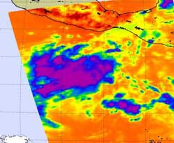
Infrared imagery on June 5 at 19:47 UTC (3:47 p.m. EDT/12:47 PDT) from the AIRS instrument that flies aboard NASA's Aqua satellite showed strong convection (purple) and thunderstorms in System 91E, about 425 miles south of Acapulco, Mexico. Credit: NASA JPL, Ed Olsen<br>
Located about 425 miles south of Acapulco, Mexico, System 91E is in a good spot for development: warm sea surface temperatures and low wind shear. Those are two factors needed to help a tropical cyclone develop.
Infrared imagery on June 5 at 19:47 UTC (3:47 p.m. EDT/12:47 PDT) from the AIRS instrument that flies aboard NASA's Aqua satellite showed a large area of strong convection and thunderstorms around the low-level circulation center of System 91E.
The National Hurricane Center gives this low a 90 percent chance of development over the next two days, and if it becomes a tropical storm it would get the name Adrian.
Media Contact
More Information:
http://www.nasa.govAll latest news from the category: Earth Sciences
Earth Sciences (also referred to as Geosciences), which deals with basic issues surrounding our planet, plays a vital role in the area of energy and raw materials supply.
Earth Sciences comprises subjects such as geology, geography, geological informatics, paleontology, mineralogy, petrography, crystallography, geophysics, geodesy, glaciology, cartography, photogrammetry, meteorology and seismology, early-warning systems, earthquake research and polar research.


Newest articles

Properties of new materials for microchips
… can now be measured well. Reseachers of Delft University of Technology demonstrated measuring performance properties of ultrathin silicon membranes. Making ever smaller and more powerful chips requires new ultrathin…

Floating solar’s potential
… to support sustainable development by addressing climate, water, and energy goals holistically. A new study published this week in Nature Energy raises the potential for floating solar photovoltaics (FPV)…

Skyrmions move at record speeds
… a step towards the computing of the future. An international research team led by scientists from the CNRS1 has discovered that the magnetic nanobubbles2 known as skyrmions can be…

