Danny the 'degenerate' followed by 2 lows
Satellite data from NOAA's GOES-East satellite at 10:45 a.m. EDT on Aug. 24, showed Danny had become stretched out into a trough of low pressure. Two other low pressure areas are developing behind it. Credits: NASA/NOAA GOES Project
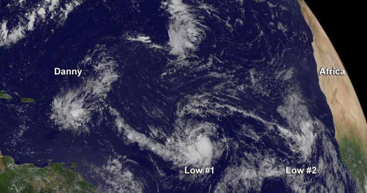
Satellite data from NOAA's GOES-East satellite at 14:45 UTC (10:45 a.m. EDT) on August 24, showed Danny had become stretched out into a trough of low pressure.
At 11 a.m. EDT (1500 UTC), the remnants of Danny were located near latitude 16.0 North and longitude 62.0 West.
The remnants are moving toward the west near 12 mph (19 kph), and this general motion is expected to continue for the next day or two. Maximum sustained winds have decreased near 30 mph (45 kph).
The National Hurricane Center said that the remnants of Danny are expected to produce 2 to 4inches of rain over the Leeward Islands, the U.S. and British Virgin Islands, Puerto Rico, and the Dominican Republic through Tuesday night, August 25.
The trough is expected to dissipate during the next couple of days.
Shower and thunderstorm activity associated with low pressure system closest to Danny's remnants were located about 950 miles east of the Lesser Antilles.
That low pressure area appears ripe for development and the National Hurricane Center (NHC) noted that the system is likely to become a tropical depression or a tropical storm during the next day or so while it moves westward near 20 mph.
The second low pressure area is associated with a tropical wave far in the eastern Atlantic Ocean. That low is located near the Cape Verde Islands is accompanied by disorganized showers and thunderstorms.
However, the NHC noted that environmental conditions are not expected to be conducive for significant development of this system while it moves westward at 15 to 20 mph over the next few days.
Media Contact
All latest news from the category: Earth Sciences
Earth Sciences (also referred to as Geosciences), which deals with basic issues surrounding our planet, plays a vital role in the area of energy and raw materials supply.
Earth Sciences comprises subjects such as geology, geography, geological informatics, paleontology, mineralogy, petrography, crystallography, geophysics, geodesy, glaciology, cartography, photogrammetry, meteorology and seismology, early-warning systems, earthquake research and polar research.


Newest articles

Properties of new materials for microchips
… can now be measured well. Reseachers of Delft University of Technology demonstrated measuring performance properties of ultrathin silicon membranes. Making ever smaller and more powerful chips requires new ultrathin…

Floating solar’s potential
… to support sustainable development by addressing climate, water, and energy goals holistically. A new study published this week in Nature Energy raises the potential for floating solar photovoltaics (FPV)…

Skyrmions move at record speeds
… a step towards the computing of the future. An international research team led by scientists from the CNRS1 has discovered that the magnetic nanobubbles2 known as skyrmions can be…

