CU-Boulder study shows Greenland may be slip-sliding away due to surface lake melt
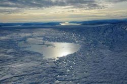
This is a surface or "supraglacial" lake on the Greenland Ice Sheet. Credit: Konrad Steffen, University of Colorado<br>
Such lake drainages may affect sea-level rise, with implications for coastal communities, according to the researchers. “This is the first evidence that Greenland's 'supraglacial' lakes have responded to recent increases in surface meltwater production by draining more frequently, as opposed to growing in size,” says CIRES research associate William Colgan, who co-led the new study with CU-Boulder computer science doctoral student Yu-Li Liang.
During summer, meltwater pools into lakes on the ice sheet's surface. When the water pressure gets high enough, the ice fractures beneath the lake, forming a vertical drainpipe, and “a huge burst of water quickly pulses through to the bed of the ice sheet,” Colgan said.
The study is being published online today by the journal Remote Sensing of the Environment. The study was funded by the Arctic Sciences Program of the National Science Foundation.
The researchers used satellite images along with innovative feature-recognition software to monitor nearly 1,000 lakes on a Connecticut-sized portion of the ice sheet over a 10-year period. They discovered that as the climate warms, such catastrophic lake drainages are increasing in frequency. Catastrophic lake drainages were 3.5 times more likely to occur during the warmest years than the coldest years.
During a typical catastrophic lake drainage, about 1 million cubic meters of meltwater — which is equivalent to the volume of about 4,000 Olympic swimming pools — funnels to the ice sheet's underside within a day or two. Once the water reaches the ice sheet's belly that abuts underlying rock, it may turn the ice-bed surface into a Slip 'N Slide, lubricating the ice sheet's glide into the ocean. This would accelerate the sea-level rise associated with climate change.
Alternatively, however, the lake drainages may carve out sub-glacial “sewers” to efficiently route water to the ocean. “This would drain the ice sheet's water, making less water available for ice-sheet sliding,” Colgan said. That would slow the ice sheet's migration into the ocean and decelerate sea-level rise.
“Lake drainages are a wild card in terms of whether they enhance or decrease the ice sheet's slide,” Colgan said. Finding out which scenario is correct is a pressing question for climate models and for communities preparing for sea-level change, he said.
For the study, the researchers developed new feature-recognition software capable of identifying supraglacial lakes in satellite images and determining their size and when they appear and disappear. “Previously, much of this had to be double-checked manually,” Colgan said. “Now we feed the images into the code, and the program can recognize whether a feature is a lake or not, with high confidence and no manual intervention.”
Automating the process was vital since the study looked at more than 9,000 images. The researchers verified the program's accuracy by manually looking at about 30 percent of the images over 30 percent of the study area. They found that the algorithm — a step-by-step procedure for calculations — correctly detected and tracked 99 percent of supraglacial lakes.
The program could be useful in future studies to determine how lake drainages affect sea-level rise, according to the researchers. CIRES co-authors on the team include Konrad Steffen, Waleed Abdalati, Julienne Stroeve and Nicolas Bayou.
Contact:
William Colgan, 303-735-3681
William.Colgan@colorado.edu
Yu-Li Liang
Yu-Li.Liang@colorado.edu
Kristin Bjornsen, CIRES science writer, 303-492-1790
Kristin.bjornsen@colorado.edu
Jim Scott, CU media relations, 303-492-3114
Jim.scott@colorado.edu
Media Contact
More Information:
http://www.colorado.eduAll latest news from the category: Earth Sciences
Earth Sciences (also referred to as Geosciences), which deals with basic issues surrounding our planet, plays a vital role in the area of energy and raw materials supply.
Earth Sciences comprises subjects such as geology, geography, geological informatics, paleontology, mineralogy, petrography, crystallography, geophysics, geodesy, glaciology, cartography, photogrammetry, meteorology and seismology, early-warning systems, earthquake research and polar research.


Newest articles

Silicon Carbide Innovation Alliance to drive industrial-scale semiconductor work
Known for its ability to withstand extreme environments and high voltages, silicon carbide (SiC) is a semiconducting material made up of silicon and carbon atoms arranged into crystals that is…

New SPECT/CT technique shows impressive biomarker identification
…offers increased access for prostate cancer patients. A novel SPECT/CT acquisition method can accurately detect radiopharmaceutical biodistribution in a convenient manner for prostate cancer patients, opening the door for more…

How 3D printers can give robots a soft touch
Soft skin coverings and touch sensors have emerged as a promising feature for robots that are both safer and more intuitive for human interaction, but they are expensive and difficult…

