Cooler Waters Help Diminish Isaac's Punch › Larger image
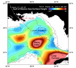
Color-enhanced image of sea surface heights in the Gulf of Mexico, showing Hurricane Isaac’s path through the Gulf and around its warmest waters. Credit: LSU Earth Scan Laboratory/U. of Colorado CCAR/NASA-JPL/Caltech <br>
In 2005, Hurricane Katrina's maximum wind speeds increased dramatically as the storm passed over a warm ocean circulation feature called the Loop Current that is part of the Gulf Stream.
The storm evolved quickly from a Category 3 to a Category 5 event on the Saffir-Simpson Hurricane Wind Scale in a matter of nine hours as it drew heat from the Loop Current. It subsequently dropped in intensity to a Category 3 storm at landfall.
Because the Loop Current and its eddies are warmer, and thus higher in surface elevation, than the surrounding waters, they are easily spotted by satellite altimeter instruments, such as those aboard the NASA/French Space Agency Jason 1 and Ocean Surface Topography Mission/Jason 2 satellites.
Scientists use the latest satellite measurements of sea-surface height from these and other satellite altimeters to create maps showing the location, direction and speed of currents in the Gulf of Mexico.
This color-enhanced image of sea surface heights in the northeastern Gulf, produced using data from available satellite altimeters, including NASA's Jason-1 and Jason-2 satellites, shows Isaac's path through the Gulf. The storm skirted around the Loop Current, then caught the outer edge of a warm eddy before passing directly over a cold eddy. The storm's track away from the Gulf's warmest waters has helped to keep Isaac from intensifying rapidly, as Hurricanes Katrina and Rita did in 2005.
Warm eddies have high heat content and great potential to intensify hurricanes, whereas cold eddies have low heat content and may even cause hurricanes to weaken, as was the case with Hurricane Ivan in 2004.
For more on NASA's satellite altimetry missions, visit: http://sealevel.jpl.nasa.gov/ .
#2012-264
Contact: Alan Buis 818-354-0474
Jet Propulsion Laboratory, Pasadena, Calif.
Alan.buis@jpl.nasa.gov
Media Contact
All latest news from the category: Earth Sciences
Earth Sciences (also referred to as Geosciences), which deals with basic issues surrounding our planet, plays a vital role in the area of energy and raw materials supply.
Earth Sciences comprises subjects such as geology, geography, geological informatics, paleontology, mineralogy, petrography, crystallography, geophysics, geodesy, glaciology, cartography, photogrammetry, meteorology and seismology, early-warning systems, earthquake research and polar research.


Newest articles

Properties of new materials for microchips
… can now be measured well. Reseachers of Delft University of Technology demonstrated measuring performance properties of ultrathin silicon membranes. Making ever smaller and more powerful chips requires new ultrathin…

Floating solar’s potential
… to support sustainable development by addressing climate, water, and energy goals holistically. A new study published this week in Nature Energy raises the potential for floating solar photovoltaics (FPV)…

Skyrmions move at record speeds
… a step towards the computing of the future. An international research team led by scientists from the CNRS1 has discovered that the magnetic nanobubbles2 known as skyrmions can be…

