Climate Change: Ocean Warming Underestimated
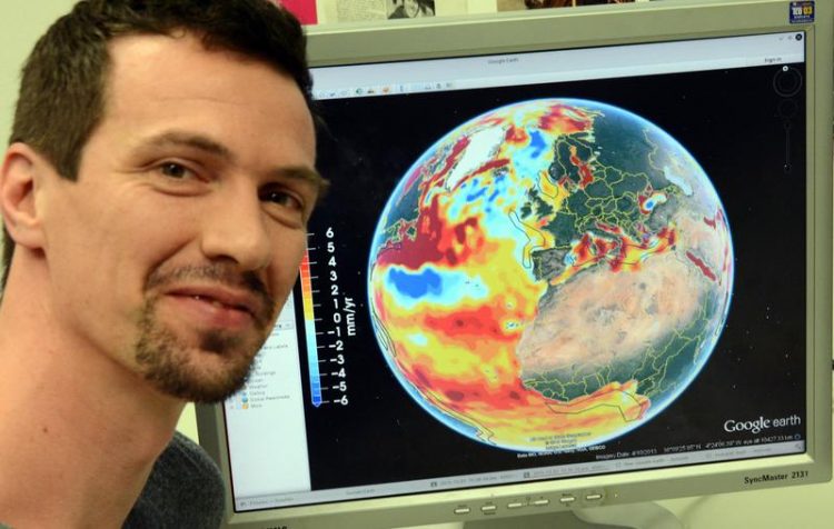
Dr.-Ing. Roelof Rietbroek from the Institute for Geodesy and Geoinformation at the University of Bonn, with a global illustration of the rise in sea levels on his computer monitor. © Photo: Johannes Seiler/Uni Bonn
In principle, water in the oceans acts like a mercury thermometer: when the temperature goes up, the liquid expands and climbs up the little tube. Since the world’s oceans are similarly locked in between the continents, their levels also rise when they heat up due to rising temperatures.
“In the deeper parts of the ocean, even a small amount of warming is enough to create a significant rise in sea level,” says Dr.-Ing. Roelof Rietbroek from the Institute of Geodesy and Geoinformation at the University of Bonn. An increase of several millimeters a year, he says, is not rare in deep-sea zones.
“To date, we have underestimated how much the heat-related expansion of the water mass in the oceans contributes to a global rise in sea level,” says Dr. Jürgen Kusche, Professor of Astronomical, Physical and Mathematical Geodesy at the University of Bonn.
Together with researchers at the Deutsches GeoForschungsZentrum (GFZ) in Potsdam and the Alfred Wegener Institute (AWI) in Bremerhaven, the geodesists used gravity field data from the GRACE satellites and sea-level measurements from the altimeters on Jason-1 and Jason-2 to calculate how much sea levels had risen, both due to warming-related expansion of the water and due to the increase of ocean mass from 2002 to 2014.
Effect is twice as large as the melting ice masses in Greenland
Until now, it was assumed that sea levels rose an average of 0.7 to 1.0 millimeters a year due to this “thermometer effect.” According to the new calculations, however, the ocean’s expansion contributed with about 1.4 millimeters a year – in other words, almost twice as much as previously assumed. “This height difference corresponds to roughly twice the volume from the melting ice sheets in Greenland,” says Dr. Rietbroek.
In addition, the sea-level rise varies strongly due to volume expansion in various ocean regions along with other effects. According to the research team’s calculations, the Philippines hold the record with about 15 millimeters a year, while the levels are largely stable on the West Coast of the United States – because there is hardly any ocean warming in that region.
Risk of storm surges could increase significantly
The main areas threatened by rising sea levels are coastal settlements, where regional changes can play a greater role than the global increase. “No country will raise its levees because of a couple of millimeters,” says Dr. Rietbroek. “But these small amounts add up to several centimeters within decades. Under such conditions, the likelihood of a destructive storm surge could increase dramatically.” From the perspective of the research team, it is thus worth keeping an eye on the expansion-related sea-level rise in the world’s oceans in light of climate change. Little measurement data is available, they say, to show how much the oceans are warming up and expanding at depths of thousands of meters in conjunction with rising global air temperatures.
“Up to now, the physical expansion processes in the deep sea have been considered only to a limited extent,” says the geodesy researcher from the University of Bonn. However, he says, they play a key role in estimating the climate effects. Therefore it would be highly interesting to observe future heat-related expansion of the world’s oceans, using new satellite missions, and to reinterpret measurement data from the past. A longer observation period will help show what proportion of the rise in sea level is due to human activity, and what proportion is due to natural causes. Dr. Rietbroek: “In addition, the estimated trend in sea level is much less affected by natural fluctuations compared to the observed trend in global temperatures, so it is a more reliable indicator of climate change.”
Publication: Revisiting the Contemporary Sea Level Budget on Global and Regional Scales, Proceedings of the National Academy of Sciences of the United States of America (PNAS), DOI: 10.1073/pnas.1519132113
Media contact:
Dr.-Ing. Roelof Rietbroek
Institute of Geodesy and Geoinformation
University of Bonn
Tel. ++49-228-733577
Email: roelof@geod.uni-bonn.de
Twitter: @r_rietje
http://store.pangaea.de/Publications/RietbroekR-etal_2015/Sealevel_pnasRietbroek… Google Earth can also be used to visualize some of the results available here
Media Contact
More Information:
http://www.uni-bonn.de/All latest news from the category: Earth Sciences
Earth Sciences (also referred to as Geosciences), which deals with basic issues surrounding our planet, plays a vital role in the area of energy and raw materials supply.
Earth Sciences comprises subjects such as geology, geography, geological informatics, paleontology, mineralogy, petrography, crystallography, geophysics, geodesy, glaciology, cartography, photogrammetry, meteorology and seismology, early-warning systems, earthquake research and polar research.


Newest articles

Solving the riddle of the sphingolipids in coronary artery disease
Weill Cornell Medicine investigators have uncovered a way to unleash in blood vessels the protective effects of a type of fat-related molecule known as a sphingolipid, suggesting a promising new…
Rocks with the oldest evidence yet of Earth’s magnetic field
The 3.7 billion-year-old rocks may extend the magnetic field’s age by 200 million years. Geologists at MIT and Oxford University have uncovered ancient rocks in Greenland that bear the oldest…

Decisive breakthrough for battery production
Storing and utilising energy with innovative sulphur-based cathodes. HU research team develops foundations for sustainable battery technology Electric vehicles and portable electronic devices such as laptops and mobile phones are…

