A Slow-moving Isaac Brings Flooding to Gulf States
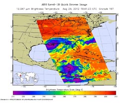
Tropical Storm Isaac continues to bring high winds and heavy rainfall to much of the Gulf Coast. The strength of the storm is reflected in this infrared image from the Atmospheric Infrared Sounder (AIRS) instrument on NASA's Aqua spacecraft. The colors represent the temperatures of the storm's cloud tops, with the highest clouds - and deepest convection - shown in shades of purple and blue. Image credit: NASA/JPL-Caltech <br>
While “only” reaching Category 1 on the Saffir-Simpson hurricane wind scale upon landfall on Aug. 28, Isaac is a slow mover, crawling along at only about six miles (10 kilometers) per hour.
This slow movement is forecast to continue over the next 24 to 36 hours, bringing a prolonged threat of flooding to the northern Gulf Coast and south-central United States.
As seen in this infrared image from the Atmospheric Infrared Sounder (AIRS) instrument on NASA's Aqua spacecraft, acquired at 2:41 p.m. CDT on Aug. 29, 2012, the large storm is still relatively well organized and is producing strong bands of thunderstorms. The broad area of purple in the image represents cloud-top temperatures colder than minus 63 degrees Fahrenheit (minus 52 degrees Celsius) around the center of the storm's circulation. It is here that Isaac's strongest storms and heaviest rainfall are now occurring.
According to the National Oceanic and Atmospheric Administration's National Hurricane Center, strong bands of thunderstorms continue to develop over water in the storm's eastern semicircle and southwest of the center. These strong rain bands are forecast to spread gradually to the west tonight across coastal southeastern Louisiana and southern Mississippi, including the New Orleans metropolitan area. The storm is expected to weaken to a tropical depression by Thursday night and a post-tropical remnant low-pressure system by Friday.
For more on NASA's Atmospheric Infrared Sounder, visit: http://airs.jpl.nasa.gov/.
#2012-270
Contact: Alan Buis 818-354-0474
Jet Propulsion Laboratory, Pasadena, Calif.
Alan.buis@jpl.nasa.gov
Media Contact
All latest news from the category: Earth Sciences
Earth Sciences (also referred to as Geosciences), which deals with basic issues surrounding our planet, plays a vital role in the area of energy and raw materials supply.
Earth Sciences comprises subjects such as geology, geography, geological informatics, paleontology, mineralogy, petrography, crystallography, geophysics, geodesy, glaciology, cartography, photogrammetry, meteorology and seismology, early-warning systems, earthquake research and polar research.


Newest articles

Bringing bio-inspired robots to life
Nebraska researcher Eric Markvicka gets NSF CAREER Award to pursue manufacture of novel materials for soft robotics and stretchable electronics. Engineers are increasingly eager to develop robots that mimic the…

Bella moths use poison to attract mates
Scientists are closer to finding out how. Pyrrolizidine alkaloids are as bitter and toxic as they are hard to pronounce. They’re produced by several different types of plants and are…

AI tool creates ‘synthetic’ images of cells
…for enhanced microscopy analysis. Observing individual cells through microscopes can reveal a range of important cell biological phenomena that frequently play a role in human diseases, but the process of…

