A NASA infrared baby picture of Tropical Depression 7E
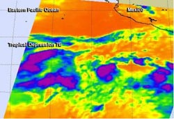
The AIRS instrument aboard NASA's Aqua satellite captured this infrared image of Tropical Depression 7E on July 30 at 4:07 a.m. EDT. Strongest storms (purple) and heaviest rains are in fragmented thunderstorms around the center.<br><br>Credit: NASA JPL/Ed Olsen<br>
The Atmospheric Infrared Sounder or AIRS instrument flies aboard NASA's Aqua satellite. AIRS creates infrared data that helps determine temperature, such as cloud top and sea surface temperatures.
AIRS captured an infrared image of Tropical Depression 7E on July 30 at 08:08 UTC/4:07 a.m. EDT. AIRS infrared data showed that the strongest storms and heaviest rains appeared in fragmented thunderstorms around the center with cloud top temperatures near -63F/-52C.
At 1500 UTC (11 a.m. EDT), newborn Tropical Depression 7E or TD7E had maximum sustained winds near 30 mph (45 kph). It was far from land and is not expected to affect any land areas as it moves farther out to sea. TD7E was centered near 12.2 north latitude and 114.9 west longitude, about 810 miles/1,300 km south-southwest of the southern tip of Baja California, Mexico. TD7E is moving to the west-northwest at 16 mph/26 kph and had a minimum central pressure of 1,008 millibars.
Forecasters at the National Hurricane Center noted in their discussion that TD7E is located in the Inter-tropical Convergence Zone or ITCZ, but has plenty of moisture and is over warm sea surface temperatures that will help it strengthen over the next couple of days.
Tropical Depression 7E is expected to move west-northwest and intensify into a tropical storm. The National Hurricane Center noted that it could later become a hurricane.
Media Contact
More Information:
http://www.nasa.govAll latest news from the category: Earth Sciences
Earth Sciences (also referred to as Geosciences), which deals with basic issues surrounding our planet, plays a vital role in the area of energy and raw materials supply.
Earth Sciences comprises subjects such as geology, geography, geological informatics, paleontology, mineralogy, petrography, crystallography, geophysics, geodesy, glaciology, cartography, photogrammetry, meteorology and seismology, early-warning systems, earthquake research and polar research.


Newest articles

Silicon Carbide Innovation Alliance to drive industrial-scale semiconductor work
Known for its ability to withstand extreme environments and high voltages, silicon carbide (SiC) is a semiconducting material made up of silicon and carbon atoms arranged into crystals that is…

New SPECT/CT technique shows impressive biomarker identification
…offers increased access for prostate cancer patients. A novel SPECT/CT acquisition method can accurately detect radiopharmaceutical biodistribution in a convenient manner for prostate cancer patients, opening the door for more…

How 3D printers can give robots a soft touch
Soft skin coverings and touch sensors have emerged as a promising feature for robots that are both safer and more intuitive for human interaction, but they are expensive and difficult…

