A double-satellite NASA-style view of the first tropical storm in eastern Pacific: Adrian
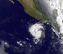
This infrared image of Tropical Storm Adrian was taken from the GOES-11 satellite on June 8 at 12:00 UTC (8:00 a.m. EDT) and shows a compact, rounded storm off the western Mexico coast. The image reveals that Adrian has some higher, stronger thunderstorms in the center that are casting shadows on lower clouds around them. Credit: Credit: NASA/NOAA GOES Project, Dennis Chesters<br><br>
Tropical Depression 1E is the first tropical depression of 2011 and formed in the eastern Pacific Ocean early on June 7. By the morning of June 8 it had strengthened into Tropical Storm Adrian, and is now forecast by the National Hurricane Center to reach hurricane strength.
This morning, the government of Mexico posted a tropical storm watch for the Mexican coast from Acapulco, west to Punta San Telmo. That means conditions are possible in the watch area from 24 to 48 hours. Meanwhile, rough surf and rip currents can be expected in the southwestern Mexican coast later today.
When the Geostationary Operational Environmental Satellite called GOES-11 passed over Tropical Storm Adrian earlier today, June 8 at 12:00 UTC (8:00 a.m. EDT), an infrared image shows Adrian as a compact, rounded storm off the western Mexico coast. GOES satellites are managed by NOAA, and images and animations are created at NASA's Goddard Space Flight Center in Greenbelt, Md. by the NASA/NOAA GOES Project.
The GOES-11 image revealed that Adrian has some higher, stronger thunderstorms around the center of circulation that are casting shadows on lower clouds around them. Those higher thunderstorms are stronger than the surrounding thunderstorms, and are likely dropping heavy rainfall (as much as 2 inches/50 mm per hour). The higher thunderstorms are also a sign that the storm continues to strengthen.
Rainfall within Adrian was captured yesterday, June 7 at 0727 UTC (3:27 a.m. EDT), when it was still Tropical Depression 1E. That's when the Tropical Rainfall Measuring Mission (TRMM) satellite flew overhead. TRMM is like a flying rain gauge in space because its precipitation radar instrument can measure rainfall rates. At that time TRMM noticed that Tropical Depression 1E had moderate rainfall surrounding its low level center. Moderate rainfall rates are between .78 to 1.57 inches (20 to 40 mm) per hour.
Adrian was already close to hurricane strength this morning, June 8. At 8 a.m. PDT (11 a.m. EDT), Adrian's maximum sustained winds were near 70 mph (110 kmh. It was about 285 miles (455 km) south-southwest of Acapulco, Mexico near 12.9 North and 100.8 West, and moving north-northwest near 5 mph (7 kmh). Minimum central pressure was 994 millibars.
The National Hurricane Center forecasts that Adrian will continue to strengthen and turn to the north-northwest, followed by a turn to the west-northwest.
Media Contact
More Information:
http://www.nasa.govAll latest news from the category: Earth Sciences
Earth Sciences (also referred to as Geosciences), which deals with basic issues surrounding our planet, plays a vital role in the area of energy and raw materials supply.
Earth Sciences comprises subjects such as geology, geography, geological informatics, paleontology, mineralogy, petrography, crystallography, geophysics, geodesy, glaciology, cartography, photogrammetry, meteorology and seismology, early-warning systems, earthquake research and polar research.


Newest articles

Silicon Carbide Innovation Alliance to drive industrial-scale semiconductor work
Known for its ability to withstand extreme environments and high voltages, silicon carbide (SiC) is a semiconducting material made up of silicon and carbon atoms arranged into crystals that is…

New SPECT/CT technique shows impressive biomarker identification
…offers increased access for prostate cancer patients. A novel SPECT/CT acquisition method can accurately detect radiopharmaceutical biodistribution in a convenient manner for prostate cancer patients, opening the door for more…

How 3D printers can give robots a soft touch
Soft skin coverings and touch sensors have emerged as a promising feature for robots that are both safer and more intuitive for human interaction, but they are expensive and difficult…

