2 NASA satellites spy Alberto, the Atlantic Ocean season's first tropical storm
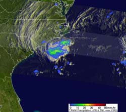
On the day Alberto formed, May 19, NASA's TRMM satellite captured a look at the rainfall rates within the first tropical storm of the Atlantic season. TRMM data showed a large area of moderate to heavy rainfall (falling at a rate of 2 inches/50 mm per hour seen in red) with a small area of heavy rainfall located near the center of the forming tropical cyclone. Light to moderate rainfall was falling at a rate between .78 inches and 1.57 inches per hour (20 to 40 mm). Credit: NASA/TRMM, Hal Pierce<br>
Tropical Storm Alberto formed 13 days before the official start of hurricane season (June 1) and ramped up quickly. Alberto's maximum sustained winds jumped to 45 mph after it developed. It was located about 140 miles east-southeast of Charleston, South Carolina, and would then take a southerly track.
On that same day, NASA's Tropical Rainfall Measuring Mission (TRMM) satellite passed over Alberto. TRMM data showed a large area of moderate to heavy rainfall with a small area of heavy rainfall located near the center of the forming tropical cyclone. Data from two instruments aboard TRMM provided the rainfall data: the Microwave Imager (TMI) and Precipitation Radar (PR) data captured at 12 minutes after midnight EDT.
On Sunday, May 20, Tropical Storm Alberto had strengthened. A Tropical Storm Watch was posted and later dropped for Savannah River to South Santee River, South Carolina. At that time, Alberto's maximum winds were near 50 mph. By mid-day, Alberto's center was located near 31.7 North and 79.3 West, about 95 miles south-southeast of Charleston, S.C. Alberto was moving west-southwest at 6 mph. Pressure 998 millibars. By 11 p.m. EDT on Sunday, May 20, Alberto appeared to become less organized and weakened. Alberto's maximum sustained winds dropped to 40 mph (65 kph) and it was centered about 85 miles (135 km) east-northeast of St. Augustine, Florida.
The Moderate Resolution Imaging Spectroradiometer (MODIS) instrument onboard NASA's Aqua satellite captured a stunning visible image of Tropical Storm Alberto off the Georgia coast on May 20 at 18:30 UTC (3:30 p.m. EDT) that showed it is a compact storm with a tight center of circulation.
On Monday, May 21, Tropical Storm Alberto was still moving southeast and is about 100 miles east-southeast of St. Augustine Florida. Alberto is causing dangerous surf conditions, including rip currents along the Georgia, South Carolina and northeast Florida coastlines.
The National Hurricane Center forecast calls for Alberto to remain off-shore from Georgia and South Carolina, and then turn to the east and then to the northeast. Although there is no expected change in the strength of Alberto as it turns, the tropical storm is churning up the waters along the coasts of South Carolina, Georgia and northern Florida, causing rough seas and rip tides.
IMAGES: http://www.nasa.gov/mission_pages/hurricanes/archives/2012/h2012_Alberto.html
Media Contact
More Information:
http://www.nasa.govAll latest news from the category: Earth Sciences
Earth Sciences (also referred to as Geosciences), which deals with basic issues surrounding our planet, plays a vital role in the area of energy and raw materials supply.
Earth Sciences comprises subjects such as geology, geography, geological informatics, paleontology, mineralogy, petrography, crystallography, geophysics, geodesy, glaciology, cartography, photogrammetry, meteorology and seismology, early-warning systems, earthquake research and polar research.


Newest articles

Superradiant atoms could push the boundaries of how precisely time can be measured
Superradiant atoms can help us measure time more precisely than ever. In a new study, researchers from the University of Copenhagen present a new method for measuring the time interval,…

Ion thermoelectric conversion devices for near room temperature
The electrode sheet of the thermoelectric device consists of ionic hydrogel, which is sandwiched between the electrodes to form, and the Prussian blue on the electrode undergoes a redox reaction…

Zap Energy achieves 37-million-degree temperatures in a compact device
New publication reports record electron temperatures for a small-scale, sheared-flow-stabilized Z-pinch fusion device. In the nine decades since humans first produced fusion reactions, only a few fusion technologies have demonstrated…

