GOES-13 sees another potential tropical depression in Caribbean Sea
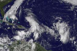
The GOES-13 satellite captured a visible image of System 97L (center) in the eastern Caribbean Sea and another low (right) behind it in the central Atlantic Ocean on Oct. 5 at 1445 UTC (10:45 a.m. EDT). Credit: NOAA/NASA GOES Project´<br>
The National Hurricane Center currently gives the low pressure area known as System 97L an “80 percent chance of developing into a tropical depression in the next 48 hours.” The low pressure area is located just north of the Virgin Islands near 19.0 North latitude and 65.3 West longitude.
The visible image from the Geostationary Operational Environmental Satellite, GOES-13 showed a tight center of circulation with clouds, showers and thunderstorms extending mostly north, east and south of the center.
The visible image also shows another area of low pressure in the central Atlantic Ocean, trailing to the east of System 97L. Forecasters are giving this low a “near zero percent” chance of developing in the next 48 hours. That low is 950 miles east of the Lesser Antilles and is a large area of disorganized showers and thunderstorms.
System 97L however, has a much greater chance because upper level winds are waning and are forecast to continue weakening. That will enable System 97L to develop further. System 97L is moving northwestward near 5 to 10 mph, and is expected to be another big rainmaker in the region. Locally heavy rainfall from System 97L is possible over the next couple of days in the Leeward Islands, the Virgin Islands, Puerto Rico and Hispaniola.
GOES-13 is operated by the National Oceanic and Atmospheric Administration, and images are created by NASA's GOES Project, located at NASA's Goddard Space Flight Center, in Greenbelt, Md.
Media Contact
More Information:
http://www.nasa.govAll latest news from the category: Earth Sciences
Earth Sciences (also referred to as Geosciences), which deals with basic issues surrounding our planet, plays a vital role in the area of energy and raw materials supply.
Earth Sciences comprises subjects such as geology, geography, geological informatics, paleontology, mineralogy, petrography, crystallography, geophysics, geodesy, glaciology, cartography, photogrammetry, meteorology and seismology, early-warning systems, earthquake research and polar research.


Newest articles

“Nanostitches” enable lighter and tougher composite materials
In research that may lead to next-generation airplanes and spacecraft, MIT engineers used carbon nanotubes to prevent cracking in multilayered composites. To save on fuel and reduce aircraft emissions, engineers…

Trash to treasure
Researchers turn metal waste into catalyst for hydrogen. Scientists have found a way to transform metal waste into a highly efficient catalyst to make hydrogen from water, a discovery that…

Real-time detection of infectious disease viruses
… by searching for molecular fingerprinting. A research team consisting of Professor Kyoung-Duck Park and Taeyoung Moon and Huitae Joo, PhD candidates, from the Department of Physics at Pohang University…

