A Labor Saving Way to Monitor Vast Rangelands
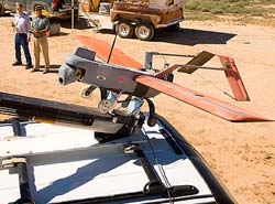
At the Jornada Experimental Range in Las Cruces, New Mexico, a team of scientists prepares to launch an unmanned aerial vehicle from a catapult. The mission: to survey vegetation on the ground in studies of vegetation changes over time. In the foreground are engineering technician Craig Winters (left) and pilot Dave Thatcher. Other researchers are in the ground control station. Photo by Stephen Ausmus<br>
Ranchers, government agencies and private land managers often need to survey vast, remote rangelands to see how they are being altered by floods, forest fires or other events. Ground-based surveys can be costly and time-consuming.
Satellite imagery is improving, but satellites can't provide the resolution needed by the Bureau of Land Management (BLM) for its assessments of millions of acres of federally owned lands, or by private land owners who want to monitor erosion control, the creep of invasive species, or other land-use changes. UAVs allow operators to survey large areas whenever they want, such as immediately after a major rain storm or forest fire.
At the Agricultural Research Service (ARS) Jornada Experimental Range in Las Cruces, N.M., Al Rango, Jeff Herrick and Craig Winters, along with Andrea Laliberte, a New Mexico State University researcher, are studying the potential effectiveness of a 20-pound UAV with a 6-foot wingspan that cruises 700 feet above the earth, collecting digital images.
ARS is USDA's principal intramural scientific research agency, and this work supports the USDA priority of improving agricultural sustainability.
UAVs are primarily being studied for their potential to collect enough information about landscape patterns to determine which areas merit closer ground level surveys, according to Laliberte.
In a study partially funded by BLM, the researchers took more than 400 aerial images of 700 acres in the Reynolds Creek Experimental Watershed in southwestern Idaho. They assembled the images into mosaics, determined the percentage of vegetation cover using image-processing techniques and compared the data to information collected with conventional ground-based techniques. In a second study, they analyzed the classification accuracy of different types of vegetation, such as mesquite and yucca plants, identified by a computer program designed to analyze mosaics assembled from hundreds of images taken during flights over tracts in Idaho and New Mexico.
Findings from the first study were published in Photogrammetric Engineering and Remote Sensing, and those from the second study were published in Geocarto International. In both studies, the researchers found the aerial data sufficiently accurate to be comparable to information gathered in ground-based surveys for shrubs, grasses and other plants that can be distinguished by their top canopy layer.
Current federal safety requirements and associated costs limit use of UAVs, but the restrictions may change in the future. This research is designed to ensure strengths and weaknesses of the technology are sufficiently understood regardless of the regulations.
Read more about this research in the September 2011 issue of Agricultural Research magazine.
Media Contact
More Information:
http://www.ars.usda.govAll latest news from the category: Agricultural and Forestry Science


Newest articles

Zap Energy achieves 37-million-degree temperatures in a compact device
New publication reports record electron temperatures for a small-scale, sheared-flow-stabilized Z-pinch fusion device. In the nine decades since humans first produced fusion reactions, only a few fusion technologies have demonstrated…
Innovative microscopy demystifies metabolism of Alzheimer’s
Researchers at UC San Diego have deployed state-of-the art imaging techniques to discover the metabolism driving Alzheimer’s disease; results suggest new treatment strategies. Alzheimer’s disease causes significant problems with memory,…
A cause of immunodeficiency identified
After stroke and heart attack: Every year, between 250,000 and 300,000 people in Germany suffer from a stroke or heart attack. These patients suffer immune disturbances and are very frequently…

