Typhoon Rammasun made final landfall near China and Vietnam border
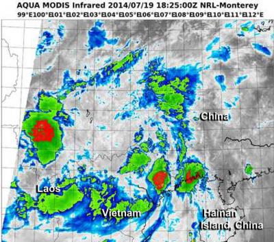
An infrared image on July 19 from the VIIRS instrument aboard NOAA-NASA's Suomi NPP satellite shows two areas of strong thunderstorms (red) in two areas near the Vietnam/China border. Credit: NRL/NOAA/NASA
NASA and NOAA's Suomi NPP satellite captured an infrared image the typhoon that showed strong thunderstorms with heavy rain potential.
Rammasun made landfall in southern China just north of the Vietnam border on July 18 at 8 p.m. EDT (July 19 at 0000 UTC). The Joint Typhoon Warning Center placed Rammasun's center near 21.9 north and 108.1 east, about 134 nautical miles (154.2 miles/248.2 km) east-northeast of Hanoi, Vietnam.
Maximum sustained winds were still near 100 knots (115.1. mph/185.2 kph) at the time of landfall. Rammasun was moving to the northwest at 15 knots (177.2 mph/27.7 kph) and was expected to dissipate over land in the next couple of days.
The China Meteorological Agency issued a red alert warning as Rammasun approached landfall on Saturday, July 19. A red alert is the highest level of warning.
When NASA-NOAA's Suomi NPP satellite passed over Rammasun on July 19 at 18:25 UTC (2:25 p.m. EDT) the Visible Infrared Imaging Radiometer Suite (VIIRS) instrument aboard captured an infrared image of the storm.
The VIIRS instrument showed three areas of powerful thunderstorms wrapping into the low-level center of circulation.
Two of those areas were along the Vietnam/China border and the other was over southwestern China, over Yun County, Yunnan, China, just north of the Laos border.
VIIRS collects visible and infrared imagery and global observations of land, atmosphere, cryosphere and oceans. VIIRS flies aboard the Suomi NPP satellite, which is managed by both NASA and NOAA.
Media Contact
More Information:
http://www.nasa.govAll latest news from the category: Earth Sciences
Earth Sciences (also referred to as Geosciences), which deals with basic issues surrounding our planet, plays a vital role in the area of energy and raw materials supply.
Earth Sciences comprises subjects such as geology, geography, geological informatics, paleontology, mineralogy, petrography, crystallography, geophysics, geodesy, glaciology, cartography, photogrammetry, meteorology and seismology, early-warning systems, earthquake research and polar research.


Newest articles

Properties of new materials for microchips
… can now be measured well. Reseachers of Delft University of Technology demonstrated measuring performance properties of ultrathin silicon membranes. Making ever smaller and more powerful chips requires new ultrathin…

Floating solar’s potential
… to support sustainable development by addressing climate, water, and energy goals holistically. A new study published this week in Nature Energy raises the potential for floating solar photovoltaics (FPV)…

Skyrmions move at record speeds
… a step towards the computing of the future. An international research team led by scientists from the CNRS1 has discovered that the magnetic nanobubbles2 known as skyrmions can be…

