Tropical Storm Maliksi forms, Iwo To on guard
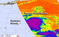
This infrared image was created from AIRS data on Oct. 1 at 02:53 UTC (10:53 p.m. EDT, Sept. 30) as Tropical Depression 20W was strengthening into tropical storm Maliksi. Strongest thunderstorms with very cold cloud top temperatures (colder than -63F/-52 C) appear in purple.<br><br>Credit: NASA JPL/Ed Olsen<br>
Tropical Storm Maliksi formed from the twentieth tropical depression of the western North Pacific typhoon season. Tropical Depression 20W formed on Sept. 20 about 305 nautical miles from Guam near 16.3 North and 149.0 East. It is moving to the north-northwest at 11 knots (12.6 mph/20.3 kph).
On Oct. 1 the depression strengthened into a tropical storm. At 1500 UTC (11 a.m. EDT) it was located near 19.3 North and 145.1 East about 50 nautical miles (57.5 miles/92.6 km) northwest of Pagan, in the Northern Marianas archipelago. It is under the jurisdiction of the Commonwealth of the Northern Mariana Islands. It had maximum sustained winds near 35 knots (40 mph/65 kph). The Marianas Islands are an arc-shaped archipelago. The island chain includes fifteen volcanic mountains.
When NASA's Aqua satellite passed over Tropical Depression 20W in the western North Pacific, it captured an infrared image with the Atmospheric Infrared Sounder (AIRS) instrument on Oct. 1 at 02:53 UTC (10:53 p.m. EDT, Sept. 30). A large area of powerful thunderstorms with very cold cloud top temperatures (colder than -63F/-52 C) surrounded the center of circulation, hinting that the storm was organizing and strengthening. It became a tropical storm hours after the image was taken.
Maliksi has organized during the morning hours of Oct. 1, with strongest convection (rising air that forms thunderstorms) and bands of thunderstorms over the southeastern quadrant. Those bands of thunderstorms, however, have not yet begun wrapping into the low level center, which is an indication that the storm still has a way to go to get fully organized.
Maliksi is expected to pass Iwo To during October 3 and strengthen into a typhoon on its journey to the northeast.
Media Contact
More Information:
http://www.nasa.govAll latest news from the category: Earth Sciences
Earth Sciences (also referred to as Geosciences), which deals with basic issues surrounding our planet, plays a vital role in the area of energy and raw materials supply.
Earth Sciences comprises subjects such as geology, geography, geological informatics, paleontology, mineralogy, petrography, crystallography, geophysics, geodesy, glaciology, cartography, photogrammetry, meteorology and seismology, early-warning systems, earthquake research and polar research.


Newest articles

Machine learning algorithm reveals long-theorized glass phase in crystal
Scientists have found evidence of an elusive, glassy phase of matter that emerges when a crystal’s perfect internal pattern is disrupted. X-ray technology and machine learning converge to shed light…

Mapping plant functional diversity from space
HKU ecologists revolutionize ecosystem monitoring with novel field-satellite integration. An international team of researchers, led by Professor Jin WU from the School of Biological Sciences at The University of Hong…

Inverters with constant full load capability
…enable an increase in the performance of electric drives. Overheating components significantly limit the performance of drivetrains in electric vehicles. Inverters in particular are subject to a high thermal load,…

