Tapah downgrades to a depression
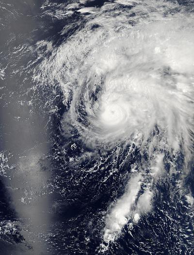
Aqua captured this image of the tropical depression Tapah on April 29, 2014, at 11:55 p.m. EDT (3:55 UTC) in the western Pacific Ocean. Credit: NASA Goddard's MODIS Rapid Response Team
Tapah rapidly dissipated due to the effected of strong vertical windshear from the west and a sharp decreased in sea surface temperature.
The storm is currently tracking northwest at 10 knots per hour and is expected to recurve to the northeast and accelerate.
Maximum wave height is currently 10 feet. The storm will be monitored for signs of regeneration.
NASA captured this image of the storm with the Moderate Resolution Imaging Spectroradiometer or MODIS instrument aboard NASA's Aqua satellite on April 29, 2014 at 11:55 p.m. EDT (3:55 UTC) in the western Pacific Ocean.
Media Contact
More Information:
http://www.nasa.govAll latest news from the category: Earth Sciences
Earth Sciences (also referred to as Geosciences), which deals with basic issues surrounding our planet, plays a vital role in the area of energy and raw materials supply.
Earth Sciences comprises subjects such as geology, geography, geological informatics, paleontology, mineralogy, petrography, crystallography, geophysics, geodesy, glaciology, cartography, photogrammetry, meteorology and seismology, early-warning systems, earthquake research and polar research.


Newest articles

Silicon Carbide Innovation Alliance to drive industrial-scale semiconductor work
Known for its ability to withstand extreme environments and high voltages, silicon carbide (SiC) is a semiconducting material made up of silicon and carbon atoms arranged into crystals that is…

New SPECT/CT technique shows impressive biomarker identification
…offers increased access for prostate cancer patients. A novel SPECT/CT acquisition method can accurately detect radiopharmaceutical biodistribution in a convenient manner for prostate cancer patients, opening the door for more…

How 3D printers can give robots a soft touch
Soft skin coverings and touch sensors have emerged as a promising feature for robots that are both safer and more intuitive for human interaction, but they are expensive and difficult…

